Trees—we literally can’t live without them. While the oxygen they provide is critical, they do much more. We won’t get into all the deep-rooted details here today, but we will address how a healthy tree canopy can decrease heat island effects. A heat island, according to the US Environmental Protection Agency, is an area where heat is intensified due to structures, such as buildings and roads, that absorb and re-emit the sun’s heat far more than natural landscapes, such as forests and bodies of water. Urban areas, where these structures are highly concentrated and greenery is limited, become “islands” of higher temperatures relative to the outlying areas. Temperatures in such heat islands can be 1 to 7 degrees higher than neighboring areas. The Detroit metropolitan area contains heat islands.
According to Vibrant Cities Lab, the City of Detroit has a 31 percent tree canopy coverage, and the American Forests organization recommends Detroit have at least a 40 percent tree canopy coverage. Without a healthy tree canopy residents of heat island areas often face:
• Increased energy consumption
• Elevated emissions of air pollutants and greenhouse gases
• Increased risk to heat related illnesses
American Forests also created a Tree Equity Score data set that describes the equity of tree cover across urban areas within the United States. The data assigns a “tree equity score” to each census block group within a city based on various factors. The tree canopy gap, defined as the potential amount of tree canopy in a given area minus the existing tree canopy is the basis for the score. The score is calculated using local physical and socioeconomic factors such as income, employment, age, race, and health, and the severity of the existing urban heat island. The Tree Equity Score is on a scale of 0-100, with a lower score meaning there is a greater priority for closing the tree canopy gap. American Forests’ goal is to see every block group have a score of 75.
METRO DETROIT TREE EQUITY SCORES
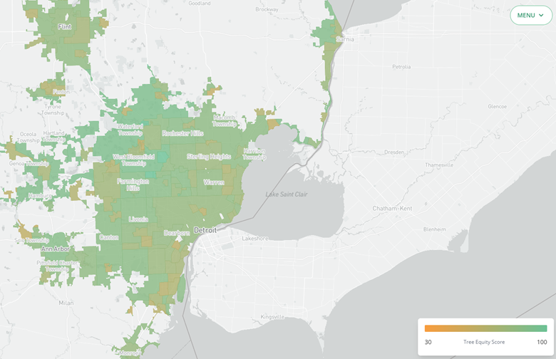
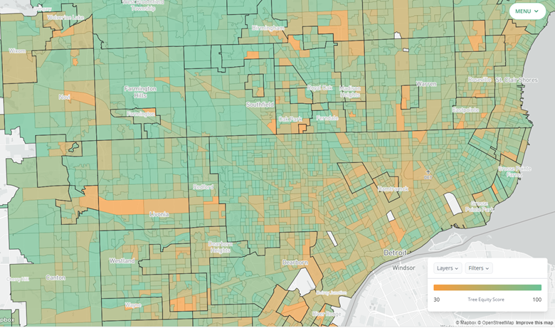
The map above shows the Tree Equity scores for much of Metro-Detroit at the municipal level. In Southeastern Michigan, at the municipal level, no community with a Tree Equity score has one less than 59, which is Carelton in Monroe County. Bloomfield Hills has a Tree Equity Score of 100, as does Bingham Farms, the highest in the region. Detroit has a score of 80, which is higher than the recommended score of 75, but a deeper look at the Detroit’s neighborhoods shows that some blocks have a score as low as 36.
According to research from Portland State University, the Science Museum of Virginia and Virginia Commonwealth University, redlined neighborhoods are hotter than the highest-rated neighborhoods by an average of almost 5 degrees. According to the article “Residential Housing Segregation and Urban Tree Canopy in 37 US Cities,” 23 percent of the redlined areas in 37 major cities (including Detroit) have a healthy tree canopy, as opposed to the 43 percent tree coverage in areas that were not redlined.
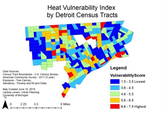
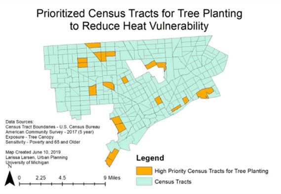
While efforts are underway in Detroit, and the Metro region, to increase tree coverage heat islands, and the concerns around them, still exist. The maps below from the City of Detroit show the heat vulnerability index by Detroit Census tracts and the prioritized Census tracts in Detroit where tree planting should occur. The Census tracts with the highest vulnerability scores (6.6-7.7) also are also the ones being prioritized for tree plantings. Why? Well, simply put, more trees in a neighborhood mean a cooler neighborhood. It also means improved air quality and can also assist with improved water quality.
With climate change not only happening, but accelerating, priorities must be placed programs such as increased tree plantings in urban areas, green infrastructure, solar panels, windmills and electric vehicles.