Metro-Detroit Economic Indicators: Home Prices Dropping, Personal Debt Increasing

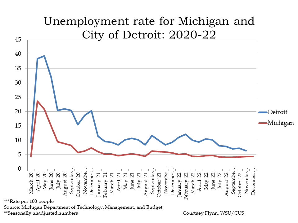
Unemployment rates for both the State of Michigan and the City of Detroit hit record lows in the second quarter of 2022.

In December of 2022 the unemployment rate for the State of Michigan was 4.3, which is inline with the State’s unemployment rate since March of 2022. In that time frame the unemployment rate for the state has only slightly fluctuated between 4.4 and 4.1 percent. For the City of Detroit, the unemployment rate for November of 2022 (December data was not yet available) was 6.4 percent.

The unemployment rate for Detroit has been regularly declining since May of 2022 when the rate was reported at 10.5 percent. In November of 2021, the unemployment rate for Detroit spike to 8.4 percent, down from the 10 percent the previous month.

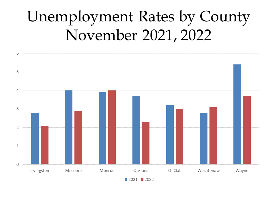
The chart below provides a more detailed look at unemployment rates throughout Southeast Michigan, both currently and a year ago. According to the data, Monroe and Washtenaw counties both had higher unemployment rates in November of 2022 than in November of 2021. For Monroe County there was only a 0.1 percent increase in the unemployment rate, with it being reported at 3.9 percent in 2021 and 4 percent in 2022. For Washtenaw County there was a 0.3 percent increase between November of 2021 and 2022. In 2022 Washtenaw County had the third highest unemployment rate in the region, falling only behind Monroe and Wayne counties. The unemployment rate for Wayne County in November of 2022 was 3.7 percent, which was the below the 5.7 percent unemployment rate the county reported in

Livingston County continued to have the lowest unemployment rate in the region at 2.1 percent in November of 2022, followed by Oakland County with an unemployment rate of 2.3 percent.

The charts below show the percent changes in the Consumer Price Index (CPI) on a month-to-month basis and a year-to-year basis for each month in years 2019, 2020, 2021 and 2022 in the Midwest Region. The CPI is a measure that examines the weighted average of prices of consumer goods and services, such as transportation, food, energy, housing and medical care. It is calculated by taking price changes for each item in the predetermined group of goods and averaging them.

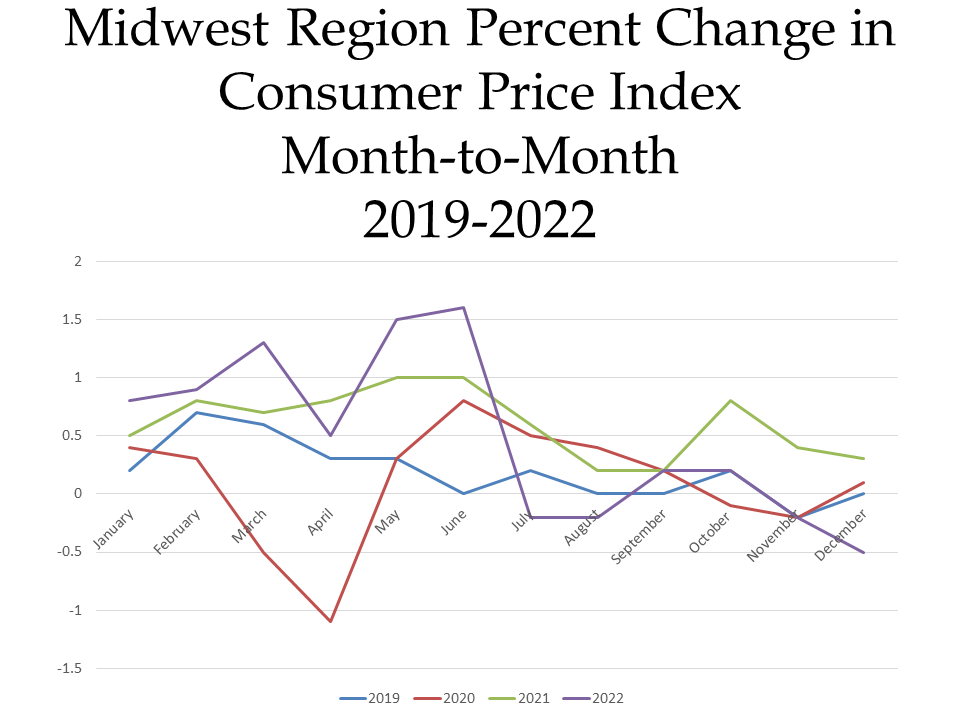
The first  chart below highlights how the CPI changed on a month-to-month basis between 2019 and 2022. Currently in 2022, the region’s prices were down 0.5 percent in the month of December. The highlights for the change include:

•Food prices increased 0.3 percent for the month of December. Prices for food at home (groceries) and away from home (restaurants) both increased 0.3 percent.
•The energy index decreased 7.2 percent in December largely due to a 15.9 percent decrease in gasoline; prices for natural gas service increased 2.8 percent though and electricity increase 1.5 percent
•There were decreases in  the cost for used cars and trucks (-2.4 percent), apparel (-1.8 percent), public transportation, and medical care (-0.3 percent).

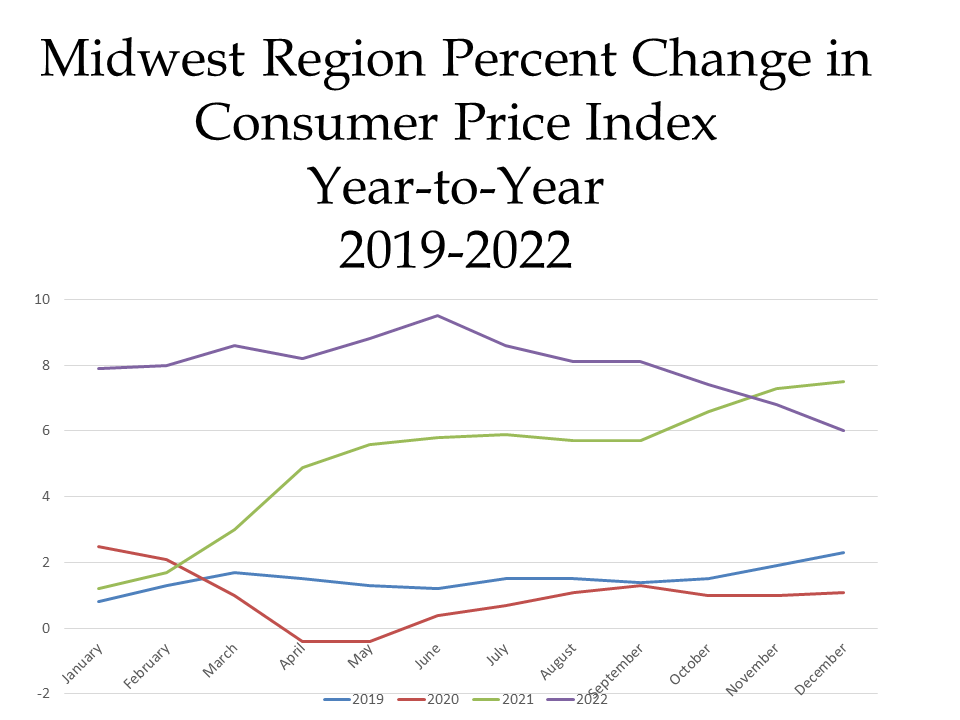
When examining the second chart, which shows how prices changed on a year-to-year basis,  we see how prices remain higher than 2019 and 2020 but that there was a decline in the CPI for the month of December between 2021 and 2022.

In December of 2022 the CPI was reported to be 6 percent above what it was the year prior. Contributing factors to the continued increase in the CPI include

•Food prices increasing 11.4 percent over the last year, with at home food prices increasing 13 percent
•Energy prices increasing 5.3 percent over the last year, with the largest contributor being natural gas (16 percent price increase)
•Rent prices increasing 7 percent
•Recreation prices increasing 6.8 percent
•The cost of used cars and trucks decreasing 9.1 percent.

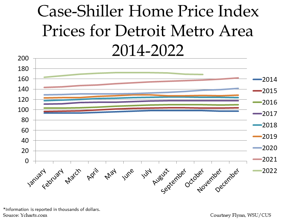
While home prices in Metro-Detroit continue to increase from one month to the next, the rate at which they are increasing is beginning to taper off. According to the Case-Shiller Home Price Index, the average price of single-family dwellings sold was $168,790 in October of 2022, a decrease of $450 for the average price of a home in September of 2022. This is the first there has been a decrease in the average home price in Metro Detroit since August of 2019. At that time home prices decreased $129,220 to $127,290. Since then though, the average price of a home continued to increase until October of 2022.

While the month-to-month trend of prices increasing broke, a look at data from year’s prior is a reminder just how much the average price of a home has increased. Between October of 2022 and 2021 the average price increased $9,200 and between October of 2022 and 2014 the price increased $70,570.

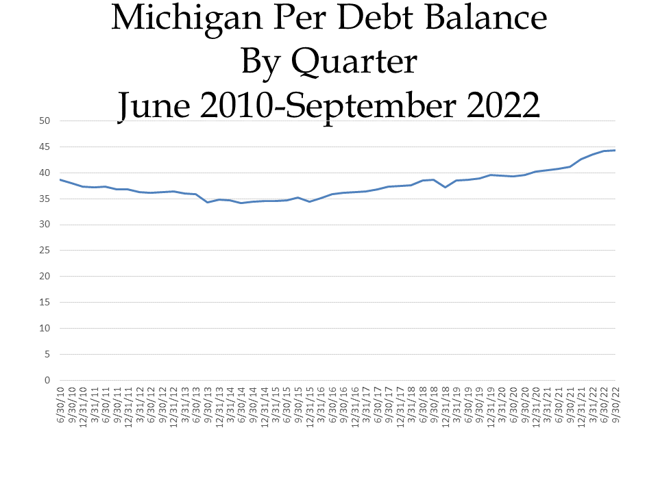
Debt for Michigan residents continues to grow, according to recent reports from the Federal Reserve Bank of New York. According to the data, the Michigan Per Capita Debt Balance came in at $44,370 at the end of the third quarter of 2022; this is an increase from the $44,130 Michigan Per Capita Debt Balance at the end of the second quarter in 2022 and from the  $41,200 debt a year prior. Overall, the Michigan Per Capita Debt Balance increase 7.69 percent between September of 2022 and September of 2021.

According to WalletHub, $86 billion in new credit card debt was incurred in 2021 in the US. A recent CNBC article noted how household debt has increased at its fastest pace in 15 years, a trend that is further demonstrated in the chart below.  Reasons for the fast-paced increase in debt include inflation and rising interest rates.

Climate Change in Michigan–Now and in the Future

Climate change is multi-faceted in both its causes and effects. In Michigan, and more specifically Metro-Detroit, many of the causes of these drastic shifts in weather patterns are the same across the globe— the continued use and overuse of fossil fuels, increased carbon emissions, desecration of natural resources. What are the effects?

Increased Average Temperature

Temperatures have already risen 2.5 degrees in Michigan. Summers are hotter, and heatwaves are stronger and last longer. Fast forward to 2100, summers in Isle Royale National Park are expected to 11 degrees hotter, according to statesatrisk.org.

The chart below shows just how Michigan’s annual daily temperatures have changed since 1900 and how they are expected to change up to 2100, depending on the amount of emissions we continue to pump into the environment. The observed data is through 2020 and shows that Michigan’s average temperature has increased by nearly 3 degrees (Fahrenheit) over time. According to the data set from The Cooperative Institute for Satellite Earth System Studies and the National Oceanic and Atmospheric Administration (NOAA), even with lower emissions temperatures are expected to increase in Michigan by a minimum of 3 degrees through 2100. That number could increase to at least 12 degrees though if the emissions we produce increase.

Increased Flooding

With increasing temperatures that means hotter air, which holds more water. More water means storms produce heavier rainstorms that are slower to move on, meaning greater accumulations of rain.

In 2020 30,000 residents of Southeast Michigan found their homes flooded. Six years earlier, in 2014, there was another great flood—these 100 year events happened within six years of each other.

According to the June 2021 report “Household Flooding in Detroit” by Healthy Urban Waters, in partnership with the Wayne State Center for Urban Studies and others, 43 percent of 4,667 Detroit households surveyed between 2012-2020 reported household flooding. Furthermore, in an online Detroit Office of Sustainability survey published in 2018, 13 percent of those survey reported they experienced flooding very often; 23 percent reported they experienced flooding somewhat often and 32 percent reported they experienced it occasionally. Additionally, a cross-sectional study published in 2016 of 164 homes in Detroit’s Warrendale neighborhood indicated that 64 percent of homes experienced at least one flooding event in during that, with many experiencing three or four events, according to the report.

The map below is a projection map developed by the Great Lakes Integrated Sciences and Assessments group that shows how precipitation is expected to increase in Southeastern Michigan and the middle of the state to about 2.25 inches between 2040 and 2059 with increased emissions. While Southeastern Michigan will face continued potential flooding events, the data prediction also shows that the western side of the state will have a decrease in precipitation.

An Increased Number of Heat Islands

A heat island, according to the US Environmental Protection Agency (EPA), is an area where heat is intensified due to structures, such as buildings and roads, that absorb and re-emit the sun’s heat far more than natural landscapes, such as forests and bodies of water. Urban areas, where these structures are highly concentrated and greenery is limited, become “islands” of higher temperatures relative to the outlying areas. Temperatures in such heat islands can be 1 to 7 degrees higher than neighboring areas. The Detroit metropolitan area contains heat islands.

Heat islands can be problematic, according to the EPA, because they can lead to increased energy consumption, increase the emissions of air pollutants and greenhouse gases and compromise water quality—all of which just further perpetuate climate change. Additionally, heat islands can have negative effects on human health. 

The map below was developed by the CAPA Heat Watch program, through a partnership with the National Integrated Heat Health Information System, NOAA Climate Program Office and the National Weather Service. This map was created from 2020 data and highlights how afternoon temperatures varied depending on the land coverage. For example, on the east side of the City, closer to the river, those areas have greater tree coverage so therefore tend to have cooler temperatures. However, areas with fewer trees, denser residential areas and wider streets have higher temperatures. As noted, this is how heat islands are created and these exist, for example, across the river from Belle Isle and several pockets on the City’s west side.

 Less, or More, Ice Coverage

According to the GLISA, the depth of a lake impacts how rapidly ice can form. So with a shallower lake, there is a greater chance of ice coverage. While depth impacts the ability for a lake to freezer over so does temperature, and with temperatures above freezing there is less to no ice coverage.  Less ice means moisture evaporates into the atmosphere easier, leading way to increased amounts of snow and rain in Michigan.

Also, according to the GLISA,  water temperatures in the fall determine the amount of evaporation from the lake surface because the temperature difference between the air and lake surface temperatures can accelerate evaporation, with warmer water temperatures resulting in greater evaporation. According to the GLISA, “the evaporation removes latent heat from the surface, resulting in a cooling of the surface, and the potential for greater ice cover. For example, if the previous winter experienced low amounts of ice cover (more solar warming), higher evaporation rates (strong cooling effect) during the fall would lead to increased ice cover the next winter. Conversely, cooler water temperatures during fall leads to lower evaporation rates (less cooling) thereby decreased ice cover.”

The effects of climate change on Michigan and Metro-Detroit are apparent with impacts on the daily lives of many. Over the next year we will dig into some of the major contributors to climate change in the region, what policies are being developed to combat the impacts climate change (and how they will work) and what the future of Metro-Detroit may be with a new climate to adapt do.


Is the Future of Southeast Michigan’s Public Transportation Regional?

The Regional Transit Authority, which is charged with coordinating regional services and developing rapid transit along Woodward, Gratiot and Michigan Avenue corridors in Macomb, Oakland, Washtenaw and Wayne counties, placed a millage on the ballot in 2016 to support such operations. That millage failed and while the sentiment for public transportation in the region has seemed to increase, we are now left wondering whether it is simply public transportation that has garnered more support, or if it is regional transportation.

Millages supporting SMART (the Suburban Mobility Authority for Regional Transportation) passed in Wayne, Oakland and Macomb counties in the November 2022 election. Since 1995 each of the three counties have passed such millages every four years to support this local transit authority, although in 2022 the margins for approval of these millages was higher only higher for Macomb County as compared to the approval rates in 2018. None the less, the millages were approved in all three counties, again, such consistency is about to change—whether it’s for the long-term better or worse remains unknown though.

For the short-term, the millage renewals will continue to support public transportation throughout Wayne, Macomb and Oakland counties, and will allow for services to be expanded. Oakland County is the key example of where services will be expanded. Once an “opt-out” county, where each municipality could decide if it wanted to leverage tax dollars to support the public transportation service, Oakland County is now a fully opt-in community. Along with ballot language that gave way to Oakland County being an opt-in county, the now approved millage language also gave way to a 10-year countywide transit millage that will levy 0.95 mills a year starting in 2023. For a home valued at $200,000 (or a home with an SEV of $100,000) the homeowner will pay $95 a year to support the newly approved SMART millage. The Oakland Transit Millage will not only support SMART but also the North Oakland Transportation Authority (NOTA), the Western Oakland Transportation Authority (WOTA) and the Older Persons Commission (OPC) in the Rochester area.

According to Oakland County, these funds levied through the approve transit millage will support services that specifically benefit Oakland County residents and businesses. With the approved millage, Oakland County transit is expected to bring in in about $66.1 million in the first year. According to Oakland County, of those funds, SMART would receive $33.3 million to maintain service and expand routes, the OPC would received $1 million, and the North and West Oakland Transportation Authorities would each receive $2 million. Additionally, $20.4 million will be allocated for new services—with the breakdown being $3.2 million for paratransit, $3.5 million for micro transit, $12 million for more routes and $1.7 million for improvements on existing routes.

Macomb County is another fully opt-in county and has been one since 1995. In November of 2022 Macomb County also approved a 0.95 millage for transit but for five years; traditionally the millages were for four years. The most recent millage passed by 66 percent; in 2018 the millage passed by a margin of only 23 votes. With the passage of this millage, the funds are to support new routes, increased access to on-demand service and improved average wait times, according to SMART.

Wayne County is now the only opt-out county that SMART services. This November voters of opt-in communities approved a four-year 0.994 mill levy that will raise about $20.2 million in its first year, according to Wayne County. In Wayne County, there are 25 communities that opt-in to SMART services, according to the SMART website. Detroit is not an opt-in community as it has its own transportation network serviced by the Detroit Department of Transportation (DDOT).

DDOT and SMART services do overlap in some areas, allowing users to easily travel to-and-from the state’s largest city on direct routes from certain other suburban communities; many of these stops are located along Gratiot, Michigan and Woodward avenues.

While transit in Macomb, Oakland and Wayne counties received continued support in the November 2022 election, the Ann Arbor Area Transit Authority did too in the August 2022 election. A new 2.38 millage was approved by Ann Arbor and Ypsilanti voters to support TheRide, which is operated by the AAATA. This five-year millage aims to improve and expand public transit service in the area. In addition to the passage of this millage, the Southeast Michigan Council of Governments also granted funds to support increasing transportation services between the cities of Ann Arbor and Ypsilanti, along with Ypsilanti Township.

Between the AAATA, SMART, DDOT, NOTA, WOTA, OPC and then Livingston County’s Livingston Essential Transportation Service (LETS), Monroe County’s Lake Erie Transit service and St. Clair County’s Blue Water Area Transit services there are at least nine different public transportation providers in the seven-county region. Then, there is also the RTA, which is meant to oversee the yet-to-be developed regional services, and has the ability to leverage additional transportation millages if approved by voters (and voted to be placed on the ballot by RTA and county leaders)

So, while the recent transit millage approvals highlight increased support for public transportation in Southeast Michigan, it also seems the infrastructure for our fragmented public transportation network is only strengthening. Various mobility options must certainly be made available to meet the differing needs of the population, but benefits may be had when our public transportation and connectivity options are guided by a regional, forward-thinking mission.

Revisiting the November Election as we Enter the 2023 Legislative Term

First the first time in about 40 years, Democrats will control the upcoming legislative session with Gov. Gretchen Whitmer winning re-election with 54.5 percent of the vote, Democrats winning 20 of the 38 seats in the State Senate and also winning 56 of the 110 seats in the State House of Representatives, according to official Michigan election results.

Prior to the election there was a buzz that Republicans may not only keep control of the legislature but also take control of the Governor seat (and the Secretary of State and Attorney General seats as well). But, that was not the case.

Some facts about the 2022 Gubernatorial Election as it pertains to Michigan, and Southeast Michigan?

Gov. Whitmer won 54.5 percent of the statewide vote and Republican opponent Tudor Dixon won 43.9 percent of the vote, according to official election results. In Southeastern Michigan four of the seven counties in the region voted in favor of Whitmer; those same counties also had a majority percent of voters vote straight party ticket for Democrats over Republicans. The voter counties in the region that voted in favor of Whitmer, and Democrats in general, were Macomb, Oakland, Washtenaw and Wayne counties.

Gov. Whitmer took the highest percentage of votes in Washtenaw County at 75.1 percent; 75.3 percent of Washtenaw County also voted straight party ticket for the Democrat party.

In Macomb County, which Gov. Whitmer also won in 2018 but where former President Donald Trump (R) won in 2016, Gov. Whitmer increased the percentage by which she won from the last time. In 2022 Gov. Whitmer took 51.8 percent of the vote in Macomb County. And, while this county did go blue, it had the lowest percentage of Democrat votes as compared to the other three counties in the region that also went blue. In Wayne County Gov. Whitmer garnered 70.8 percent of the vote and in Oakland County she garnered 61 percent of the vote.

Reports indicate that garnering majority of the votes from Macomb and Oakland counties played key roles in Gov. Whitmer’s win. According to MLive, the last time a candidate won the governor’s election while losing Oakland County was in 1982.

On the other side, of the seven counties in the region it was Livingston County where Dixon garnered the highest percentage of votes at 65.5 percent. In St. Clair County she had 57.8 percent of the vote and in Monroe County she had 55.5 percent of the vote.

St. Clair County had the highest percentage of straight party ticket Republican votes at 64.4 percent.
When examining the results for the State legislature we know that nearly a majority of those who returning to the State legislature are incumbents ( 53 incumbents in the 110 person House of Representatives and 22 incumbents in the 38 person State Senate). Furthermore, of the 53 House of Representatives incumbents, 20 are Democrats and 18 are Republicans. The make up of the 22 State Senate incumbent roster is 11 of whom are Republicans and 11 who are Democrats. Overall though, according to Bridge Michigan, 10 percent of incumbents who ran for re-election this year lost in either the primary or general election. One such incumbent at the Senate level was Mike MacDonald (R-Macomb Township). With the redistricting of legislative seats, MacDonald faced (state legislator) newcomer Veronica Klinefelt (D); Klinefelt garnered 53 percent of the vote and MacDonald garnered 42 percent.
As noted, Macomb County went blue for several state related races, but at the local level the Macomb County Board of Commissioners remains controlled by the Republicans and at the Congressional level a Republican won the race for the new 10th Michigan Congressional District.  

In Macomb County, Congressman-elect John James (R) won 48.6 percent of the vote and his opponent Carl Marlinga (D) took 48.4 percent of the vote in Macomb County. For the entire district, which spans into the Rochester area as well, Marlinga won 48.8 percent of the vote.

With the next legislative term ready to begin, agendas and priorities are already being discussed at the national, state and local levels. Key priorities Drawing Detroit will be giving keen attention to in the coming year include climate change topics such as heat islands, flooding, changing water, carbon and temperature levels, electric vehicle fleets and more.