Populations Living with Disabilities, in Poverty Overlap in Metro-Detroit

In 2016 Royal Oak Charter Township had the highest percentage of residents with disabilities at 29 percent, according to the U.S. Census Bureau. The five cities in the region with the highest percentage of residents with disabilities were:

Royal Oak charter township 29
Hazel Park city 25.8
Port Huron city 23.7
Memphis city 22.6
Highland Park city 22

According to the U.S. Census Bureau, the determination of an individual’s disability status is complex, as it is an umbrella concept that covers various aspects of an individual’s health. For the American Community Survey (ACS), the data set on which this post is based, individuals self-report if they have a disability based on standardized questions from the U.S. Department of Health and Human Services, per section 4302 of the Affordable Care Act.

Regionally, the average percentage of residents with a disability was 12.5 percent. Of the 210 communities for which data was available, 90 communities had more than 12.5 percent of the population classified as having disabilities. The map shows that the eastern portion of the region, from Monroe County up through St. Clair County, had the most communities in Southeastern Michigan with above average percentages of residents with disabilities. Several of these communities also had among the highest poverty rates.

The City of Detroit is an example of a community with above average disability and poverty rates. In 2016, 21.7 percent of the population in Detroit had a disability, and 39.4 percent were living at or below the poverty level. The average poverty rate for Southeastern Michigan in 2016 was 10.3, according to the ACS. The second map below further highlights how the Census tracts with among the highest percentages of the population living with a disability also had some of the highest rates of those residents living in poverty. There were 30 Census tracts where between about 68 and 86 percent of the populations had a disability and was living in poverty. Conversely, there were also about 29 Census tracts where less than 30 percent of the population had a disability and was living in poverty. Overall though, majority of the Detroit’s population that had a disability was living in poverty, according to the 2016 ACS data.

Research shows that those living in poverty have a higher risk of having a disability because they have more limited access to basic necessities (clean water, health care), are more likely to live in more dangerous environments (low quality housing, closer to natural disaster zones and environmental hazards) and are more likely to accept high risk jobs. Conversely, people with a disability have a higher chance of living in poverty due to higher costs of living as it relates to medical care and the limited opportunities that may occur due to the disability. Disability can, thus, be viewed as both a cause and consequence of poverty.

The information below shows the communities with the highest disability rates in the region, along with their poverty rates. All five of the communities, with the exception of Memphis, had above average disability and poverty rates. In 2016, the average percentage of residents in Southeastern Michigan living with a disability was 12.5, and the average percentage of residents living below the poverty line was 10.3.

Disability Rate Poverty Rate
Royal Oak Charter Township 29 31.5
Hazel Park 25.8 25.2
Port Huron 23.7 27.8
Memphis 22.6 8.8
Hazel Park 22 46.8


Overall, these data add to the narrative that poverty is a cause and consequence of disability.

Monroe’s Water Lead Levels Highest in Southeastern Michigan

In 1991 the Lead and Copper Rule was implemented by U.S. Environmental Protection Agency as a means to help prevent exposure to lead and copper. According to the rule, if lead concentrations in drinking water exceed 15 parts per billion (ppb) in more than 10 percent of customer’s taps sampled, additional controls must be taken to prevent corrosion. According to a recent MLive article, which compiled Michigan Department of Environmental Quality lead testing data from water systems throughout the State of Michigan, the City of Monroe was the only public water system in Southeastern Michigan that had lead levels that reached the federal threshold. According to the data, which states testing ended on Dec. 31, 2016, the City of Monroe’s 90th percentile for lead was 15 ppb. For comparison, the data showed that between January and June of 2017 Flint’s 90th percentile for lead was 7 ppb.

In Southeastern Michigan, there were only three public water systems (for which data was available) with lead concentration levels above Flint’s. Those systems were located in:

  • Grosse Pointe Shores: 9 ppb
  • Capac: 7ppb
  • Marysville: 12 ppb

Conversely, there were 77 public water systems in Southeastern Michigan for which data was available, with zero lead tested in the water system.

While the data shows the lead levels are improving in Flint, this data also shows how the region’s, and the state’s, water systems need continuous monitoring and the infrastructure needs regular maintenance. According to a Brookings article (link), the federal government is only responsible for less than a quarter of the spending on all 51,000 plus public water systems in the country. This means, local and state governments must bare the brunt of the cost to ensure citizens have access to a clean, reliable water source. In Southeastern Michigan, a large portion of the region’s water system is overseen by the Great Lakes Water Authority. This government agency is regional authority that was created to ensure larger purchasing power is available for infrastructure improvements. This is one step the region has taken in recent years to ensure clean water remains available to the residents of Southeastern Michigan.

Southeastern Michigan’s Population Slightly Increases, Auto Sales and Unemployment Decreases

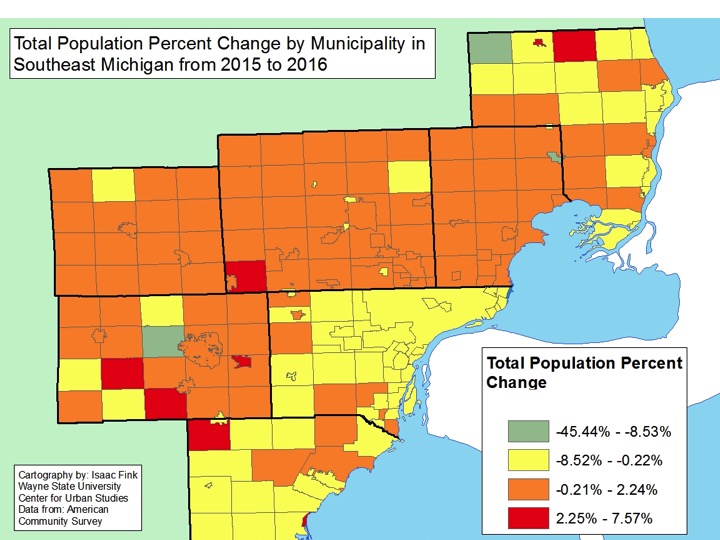
  • Detroit and Wayne County suffered the loss of populations between 2015 and 2016, while some of the region’s outermost communities experienced growth;
  • The unemployment rate decreased at the State and local levels(monthly);
  • Regionally, Livingston County’s unemployment rate remains the lowest;
  • The Standard and Poor’s Case-Shiller Home Price Index for the Detroit Metropolitan Statistical Area shows home prices continue to increase monthly and annually while national mortgage rates are became higher than those throughout the State and the City of Detroit.
  • Auto sales took a dip between 2016 and 2017, while employment in auto manufacturing increased

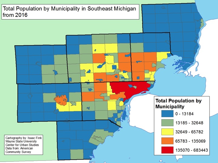
The City of Detroit remained the most populated City in Michigan, according to 2016 Census data. However, Detroit’s population numbers continued to decline. In 2016, it was reported that the City of Detroit had a population of 683,443 and in 2015 the population was at 690,074. This 6,631 person population loss was equivalent to nearly a 1 percent loss in population. Aside from Detroit remaining as the most populated city regionally, and statewide, the other four of the top five most populated cities in Southeastern Michigan were: Warren (135,069), Sterling Heights (131,674), Ann Arbor (118,087) and Clinton Township (99,193). Of all the five communities, Detroit was the only City to lose residents. Of the 210 communities for which data was available was available for, 98 lost residents between 2015 and 2016.

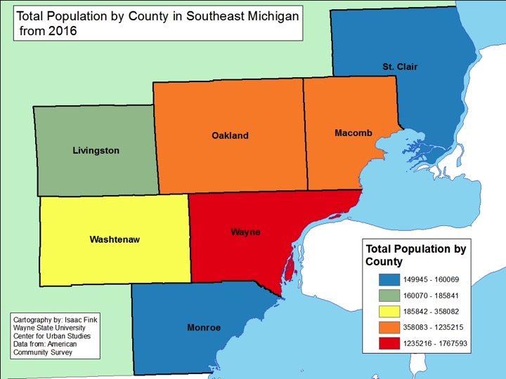
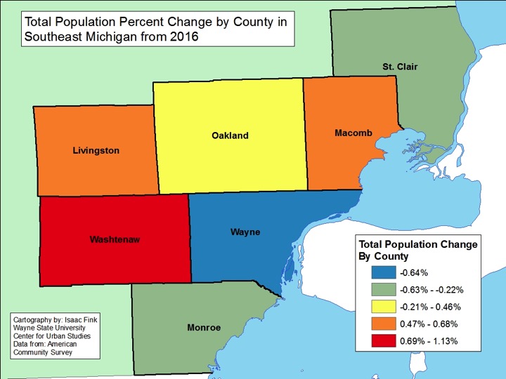
Overall, while population gain, and loss, between cities wasn’t extreme, the trend of some of the region’s most rural communities growing continued. For example, Greenwood Township in St. Clair County grew by about 800 people, which was about an 8 percent increase. In terms of percent change, the top 10 communities that experienced growth, ranging from percent change increases of 5.8 to 1.8 percent, were all located outside of the region’s urban centers, with the exception of Ypsilanti. This narrative is further strengthened by the fact that, at the County level, four counties that grew in population between 2015 and 2016. Those four were Oakland, Washtenaw, Livingston and Macomb counties. As the map shows, majority of the communities in these counties experienced no more than a 0.21 population loss, if a loss occurred at all. In terms of percent change, Washtenaw County grew the most at 1.13 percent, which was equivalent to an additional about 4,000 people calling Washtenaw County home. Conversely, Wayne County experienced the greatest population loss in the county at -0.64 percent, which was equivalent to about a 11, 375 people leaving the county between 2015 and 2016. Despite the population loss, Wayne County remains the most populated county in the region with 1,767,593 residents.

When examining the bigger picture, the data shows that, as a whole, Southeastern Michigan grew by about 3,700 residents between 2015 and 2016. In 2016 there were 4,716,448 residents and in 2015 there were 4,712,709.

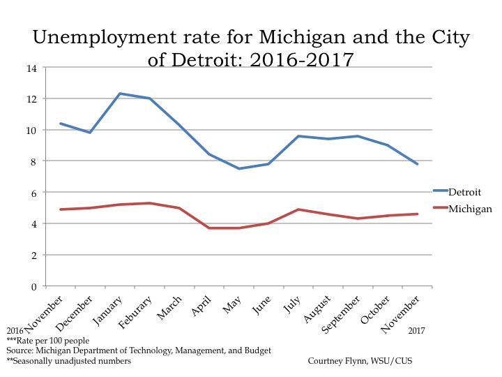
In November of 2017 the unemployment rate for the State of Michigan was 4.6, a slight increase from the October unemployment rate of 4.5, according to the most recent data provided by the Michigan Department of Technology, Management and Budget. The State unemployment rate for November was 0.3 points below what it was in November of 2016.

The City of Detroit unemployment rate was reported to be 2.6 points lower in November of 2017 than what it was reported at in November of 2016. For November 2017 the unemployment rate was reported at 7.8; in 2016 it was reported to be 10.4.

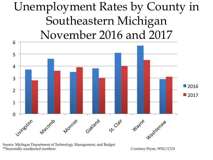
The chart above displays the unemployment rates for each of the seven counties in Southeastern Michigan for November of 2016 and 2017. Wayne County had the highest unemployment rates for both 2016 and 2017 (5.7 and 4.5 percent, respectively). In November of 2017, Livingston County had the lowest unemployment rate at 2.8 while Washtenaw County had the lowest rate in 2016 at 2.9. By November of 2017, Washtenaw County’s unemployment rate increased to 3.1. In November of 2017, Washtenaw and Monroe counties were the only two in the region that had unemployment rates higher than in November of 2016.

Wayne and St. Clair counties were the only two in the region with unemployment rates at or above 4 percent in 2017.

Wayne County had the largest unemployment rate decrease between November 2016 and 2017 at 1.3. In November of 2017 Wayne County had a unemployment rate of 4.5, and in 2016 that rate was 5.7.

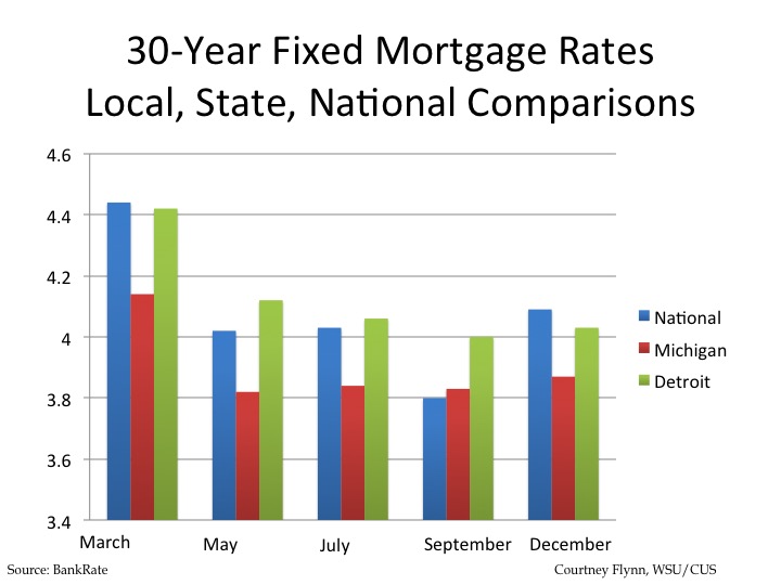
Data on the national, state and local average 30-year mortgage interest rates show rates increasing across all three from September to December. These rates were provided by bankrate.com, which does a national survey of large lenders on a weekly basis. As a 30-year fixed rate mortgage is the most traditional form of home financing, we chose it to show the rate differences.

It was the national interest rate with the highest average for in December of 2017 at 4.09, which was 1.1 points higher than the last time we examined this data, which was in September of 2017 .

In December of 2017 Detroit’s average 30-year fixed mortgage interest rate was 4.03, a rate that was higher than the state average. It showed an increase after declining from March through September.

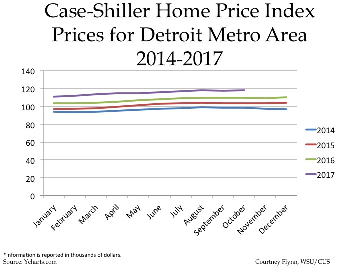
The above charts show the Standard and Poor’s Case-Shiller Home Price Index for the Detroit Metropolitan Statistical Area. The index includes the price for homes that have sold but does not include the price of new home construction, condos, or homes that have been remodeled.

According to the index, the average price of single-family dwellings sold in Metro Detroit was $117,850 in November 2017; this was $1,170 higher than the average family dwelling price in May. Also, the November 2017 price was an increase of $8,060 from June of 2016 and an increase of $14,440 from November of 2015 and an increase of $20,560 from November of 2014.

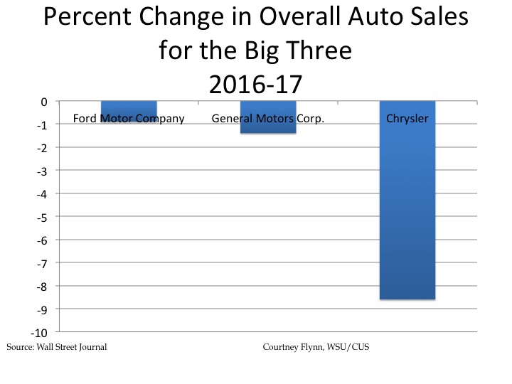
According to data from a recent Wall Street Journal article, overall year-to-date auto sales for the Ford Motor Company, General Motors and Chrysler all declined between 2016 and 2017. This data includes sales of domestic and import cars and trucks. Chrysler suffered the biggest hit, according to the data, with an 8.9 percent total decrease in sales. Ford suffered a .9 percent decrease in sales and General Motors suffered a 1.4 percent decrease.

Of all the automotive companies, American and international, General Motors had the largest percent of market share in 2017 at about 17 percent with about 3 million sales.

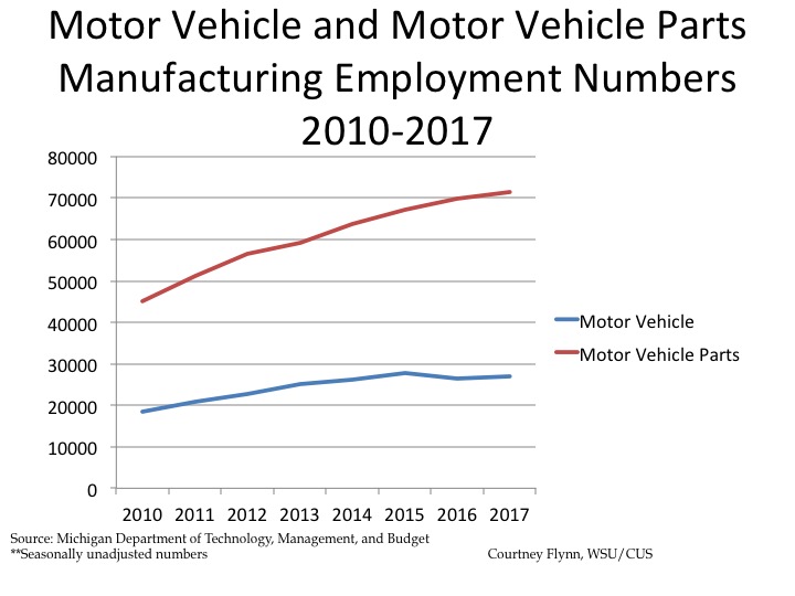
Between 2010 and 2017 employment in both the motor vehicle and motor vehicle parts manufacturing employment sectors has grown in the Detroit Metropolitan Statistical Area. In 2010 there were 45,100 employees in the motor vehicle employment manufacturing sector and 18,400 in the motor vehicle parts manufacturing sector for an over all total of 63,500. By 2017 there 71,500 employees in the motor vehicle manufacturing employment sector, a number that has steadily increased over the last eight years. For the motor vehicle parts manufacturing sector there were 27,100 employees. The total across both sectors in 2017 was 98,600. So, compared to 2010, these two have increased overall by 35,100, more than 50 percent. However, the rate of increase for vehicle manufacturing has slowed, while the rate for parts manufacturing has stabilized, after a slight drop.

Food Least Accessible for Detroit in Southeastern Michigan

Throughout Southeastern Michigan the City of Detroit had the highest number of Census tracts with the lowest access to food sources, according to 2015 data from the U.S. Department of Agriculture (USDA). For the purpose of this post, low income is defined as Census tracts with a poverty rate of 20 percent of higher or with a median family income less than 80 percent of median family income for the state or metropolitan area. Areas with low access to food are identified as Census tracts having 33 percent of the population living within a certain mileage from a grocery store. In this post these areas are identified by either being a half-mile or mile from a grocery store in an urban area and 10 miles in a rural area (these differences are identified in each map below). According to the USDA, none of the counties and/or Census tracts in Southeastern Michigan are identified as rural, so the 10 mile rural identifier will not be used in this post.

Half-mile  Mile

When examining the Southeastern Michigan region for the number of Census tracts with low-income families and low access to food sources within a half-mile majority of the City of Detroit is highlighted in the map below, in addition to Hamtramck and Highland Park. There were also several Census tracts just outside the border of Detroit, in areas including Warren, Eastpointe, Dearborn, Hazel Park and Southfield, that had low incomes and low access to reliable food sources. While there were several Census tracts in every one of the seven counties in the Southeastern Michigan region, it was Wayne County that had the had the highest number of residents with low incomes and low access to grocery stores within a half-mile of residents’ homes.

A closer look at just the Census tracts in the City of Detroit show that there were only a select number of pockets in the City that were not considered low income and also had access to a grocery store closer than a half-mile. One such area that stands out is the downtown area. Other areas include the Denby, Cody Rouge and West Village neighborhoods.

In Washtenaw County, it was the Ann Arbor/Ypsilanti area that had the highest number of Census tracts with low-income families not having access to grocery stores and in Oakland County, beyond those Census tracts that border Detroit, it was the Pontiac that had the most number of low-income residents with low access to food options. In the less densely populated counties in the region (Monroe, St. Clair, Livingston) there was an average of about three Census tracts with a poverty rate of 20 percent of higher or with a median family income less than 80 percent of median family income and access to a grocery store more than a half-mile away.

One Mile

When the radius was expanded to one mile, the number of Census tracts without access to grocery stores dramatically decreased. The most notable decrease in the region was in the City of Detroit. In the maps below there are only about 20 Census tracts in the City of Detroit with a poverty rate of 20 percent of higher or with a median family income less than 80 percent of median family income and access to a grocery store more than a mile away. In the maps above, which depict access within a half-mile, nearly the entire City is highlighted for low income and low access. A notable difference due to access between a half-mile and mile can also be seen in the Ypsilanti/Ann Arbor area.

Throughout Livingston, Monroe and St. Clair counties there was a minimum decrease in the number of Census tracts with a poverty rate of 20 percent of higher or with a median family income less than 80 percent of median family income and access to a grocery store more than a half-mile away.

Low Income and Low Vehicle Access

The maps below identify low-income Census tracts where more than 100 housing units did not have a vehicle and were more than a half-mile from the nearest grocery store. When applying these variables we see there was an overall fewer number of Census tracts without access than when only looking at access, despite transportation accessibility. This was particularly true throughout Wayne County and in Census tracts just north of Wayne County. In Detroit, the highest concentration of Census tracts with more than 100 housing units not having a vehicle and that were more than a half-mile from the nearest grocery store were those on the west side of the City along Livernois Avenue.

In examining the data provided by the USDA, we see that regionally it was the City of Detroit, its inner-ring suburbs that had the highest number of low-income families with among the lowest access to food due to the location of grocery stores in 2015. To help support access to grocery stores, a robust public transportation network could be one solution, particularly in Detroit and its surrounding cities. Additionally, it is also important to understand the impact low incomes have on families when it comes to accessing healthy foods. While grocery stores may be within a half-mile or mile from a home, once an individual reaches a grocery store the chances of them purchasing fresh, non-processed foods may not be as high due to cost, and quite possibly access within the store. To support access to fresh foods in urban areas like the City of Detroit the Detroit Food Justice Task Force recommends policies that allow for more support of neighborhood famers markets and small businesses and research that identifies the food needs of neighborhoods throughout the City.

Maternal Deaths Highest in Detroit

A look into the pregnancy related death rates in Southeastern Michigan showed that the City of Detroit had higher rates from 2008-13 (combined) than any other governmental unit reported for the region. The Michigan Department of Health and Human Services says pregnancy related deaths are those when a woman dies while pregnant or within one year of pregnancy from any cause related to, or aggravated by, pregnancy or its management. According to MDHHS data, the pregnancy related death rate for Detroit was 44.4 per 100,000 babies from 2007-13 (44.4 total). Pregnancy associated deaths, by contrast are those that occur while a woman is pregnant or within a year of pregnancy irrespective of cause; these deaths can include suicide, drug overdoses or medical causes such as cancer. The rate for Detroit was 62.7 per 100,000 babies for pregnancy associated deaths (48 total) from 2007-13. When comparing pregnancy associated deaths and pregnancy related deaths, the data shows that there were overall higher rates for pregnancy associated deaths. This is likely because pregnancy associated deaths encompasses a broader range of causes of death.

As stated, the data provided by the Michigan Department of Health and Human Services shows that Detroit had the highest rate of pregnancy related death and pregnancy associated death rates in the region. For pregnancy related deaths, Wayne County had the lowest rate at 9.5 per 100,000 babies (9 total), for the counties where data were available. Wayne County’s rate excludes the deaths in the City of Detroit. In Southeastern Michigan pregnancy related rates for Livingston, Monroe, St. Clair and Washtenaw counties were not available because there were five or less deaths.

For pregnancy associated deaths Oakland County had the overall lowest rate at 28.6 (7 total). In Southeastern Michigan, pregnancy associated rates for Livingston, Monroe and Washtenaw counties were not available because there were five or less deaths.

According to an article from the Detroit News, high maternal death rates are related to chronic health conditions and high rates of poverty, both of which are common in Detroit.

The Michigan Department of Health and Human Services does not have data for 2014 and 2015 because it had not been reviewed by the State’s maternal death committees, as of early December, according to a representative from the department. In early 2017, Public Act 479 of 2016 was signed into law making maternal death reporting mandatory. Prior to this law reporting was voluntary.