Environmental Injustices Continue in Detroit

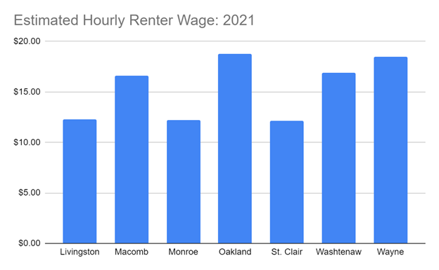
Environmental injustice occurs when certain populations, typically those who are marginalized, and the environment are both harmed from certain actions. We have seen this occur with the Flint water crisis and we continue to witness it right here in Detroit. While pollution can come in many forms, it is air pollution that we are focusing on in this post and what is at least one factor in Detroit’s environmental injustice.

Before we dive into some of the sources of Detroit’s air pollution it is important to understand Detroit’s socioeconomic makeup. With a population of about 620,000 residents, 78 percent of the population is black, nearly 25 percent of the population is under the age of 18 and 32 percent of the population lives in poverty, according to the US Census Bureau.

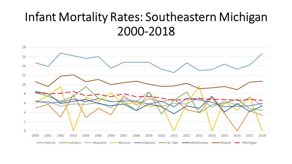
Furthermore, according to the University of Michigan School of Public Health it is estimated that air pollution kills more than 650 Detroiters a year, with thousands more being hospitalized and children missing a disproportionate number of days at school because of illnesses and asthma.

According to the 2021 update on the State of Michigan’s “Detroit: The Current Status of Asthma Burden,” the asthma rate of the in the City of Detroit in 2019 was four times higher than the State of Michigan’s rate. Additionally, there were 1,458 asthma hospitalizations of Detroit residents in 2019.

Between 2017 and 2019, 71 Detroit residents died due to asthma. The rate of asthma mortality among Detroit residents was 31.4 per 1,000,000 population. The rate of asthma mortality in Detroit in 2017-2019 was about three times the rate for Michigan as a whole.

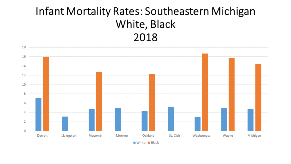
Now, when further digging into asthma rates el, the “Detroit: The Current Status of Asthma Burden,” states that in 2019, the rate of asthma hospitalization among Detroit’s Black population was 31 per 10,000 while the rate among Detroit’s white population was 7.9 per 10,000.  Asthma hospitalization among Detroit Blacks were over three times that of Detroit whites. Michigan Blacks had over five times the hospitalization rate of Michigan whites.

According to the American Lung Association, the exact cause of asthma remains unknown, but there are certain factors that play a role in developing the disease. These factors include family history, allergies, viral respiratory infections, obesity, smoking, certain jobs and air pollution, especially including dust and mold.

As noted in our last post, there are several secondary particle pollution sources that have a negative impact on the area’s air quality in Metro-Detroit. According to climatetrace.org, a global non-profit organization that independently traces greenhouse gas emissions, some of the area’s highest emitters are an oil refinery, two steel plants, an airport and a powerplant. These emitters are:

Marathon Petroleum CO Detroit:

Ranked 378/80,188 Worldwide: for Carbon Dioxide emissions (CO2E)

Cleveland-Cliffs Dearborn Steel Plant

Ranked 296/80,188: for Carbon Dioxide emissions (CO2E)

Detroit Metropolitan Wayne County Airport

Ranked 917/80,188 for Carbon Dioxide emissions (CO2E)

Gerdau Monroe Steel Plant

Ranked 1,450/80,188 for Carbon Dioxide emissions (CO2E)

Monroe Michigan Power Plant (DTE)

Ranked 37/80,188 for Carbon Dioxide emissions (CO2E)

Other secondary sources that contribute to particle pollutants in the Metro-Detroit are the the Mistersky and River Rouge power plants, highways, the Ambassador Bridge and Stellantis manufacturing plants in Warren and on Detroit’s eastside.

The media has long reported the history of the Detroit’s 48217 ZIP code, which is located in Southwest Detroit. With the Marathon plant and the DTE Delray and Mistersky powerplants, along with nearby highways and international trucking routes (Ambassador Bridge and soon to be Gordie Hower International Bridge), the amount of air pollution in this area is at concerning levels.

According to a recent released by the University of Michigan School of Public Health, between 2016-2021 the major source of PM2.5 ( which is fine inhalable particles, with diameters that are generally 2.5 micrometers and smaller) in the area was “mobile sources of emissions,” or vehicle exhaust and construction equipment, at 40 percent. Industrial sources of emissions also contributed a “sizable” amount to the PM2.5 levels, but were on the decline due to recent closures of coal-burning power plants and other facilities in the area.

Another area of growing concern is Detroit’s eastside, where the Stellantis production plant has not only grown to two production lines, but the amount of traffic has also increased due to the addition of a logistics warehouse that services the Stellantis plant. As has been noted in this and previous air quality posts, high traffic and industrial areas are major factors in both environmental pollution and an individual’s health.

So, what we know thus far is that Detroit is a primarily a city composed of minorities, particularly African-Americans and Hiuspanics with a lower median income than neighboring communities in Southeast Michigan. We also know that in Detroit there are pockets of dedicated space for industry, whether it be manufacturing plants, power plants or other forms that push PM2.5 into the air. Poor air quality is not only a major concern for many Detroit residents, but also a reality. This type of environmental injustice has led to severe health problems for thousands of residents, both children and adults.

With strong regulations, from zoning to emission standards and even traffic regulations, we can work toward alleviating environmental injustices. However, as we continue to see at an increasing rate, pollution and other negative impacts on the environment have a long-lasting impact. Advocating for and taking steps to implement equitable solutions when it comes to housing, education and access to jobs is crucial.

Is the Future of Southeast Michigan’s Public Transportation Regional?

The Regional Transit Authority, which is charged with coordinating regional services and developing rapid transit along Woodward, Gratiot and Michigan Avenue corridors in Macomb, Oakland, Washtenaw and Wayne counties, placed a millage on the ballot in 2016 to support such operations. That millage failed and while the sentiment for public transportation in the region has seemed to increase, we are now left wondering whether it is simply public transportation that has garnered more support, or if it is regional transportation.

Millages supporting SMART (the Suburban Mobility Authority for Regional Transportation) passed in Wayne, Oakland and Macomb counties in the November 2022 election. Since 1995 each of the three counties have passed such millages every four years to support this local transit authority, although in 2022 the margins for approval of these millages was higher only higher for Macomb County as compared to the approval rates in 2018. None the less, the millages were approved in all three counties, again, such consistency is about to change—whether it’s for the long-term better or worse remains unknown though.

For the short-term, the millage renewals will continue to support public transportation throughout Wayne, Macomb and Oakland counties, and will allow for services to be expanded. Oakland County is the key example of where services will be expanded. Once an “opt-out” county, where each municipality could decide if it wanted to leverage tax dollars to support the public transportation service, Oakland County is now a fully opt-in community. Along with ballot language that gave way to Oakland County being an opt-in county, the now approved millage language also gave way to a 10-year countywide transit millage that will levy 0.95 mills a year starting in 2023. For a home valued at $200,000 (or a home with an SEV of $100,000) the homeowner will pay $95 a year to support the newly approved SMART millage. The Oakland Transit Millage will not only support SMART but also the North Oakland Transportation Authority (NOTA), the Western Oakland Transportation Authority (WOTA) and the Older Persons Commission (OPC) in the Rochester area.

According to Oakland County, these funds levied through the approve transit millage will support services that specifically benefit Oakland County residents and businesses. With the approved millage, Oakland County transit is expected to bring in in about $66.1 million in the first year. According to Oakland County, of those funds, SMART would receive $33.3 million to maintain service and expand routes, the OPC would received $1 million, and the North and West Oakland Transportation Authorities would each receive $2 million. Additionally, $20.4 million will be allocated for new services—with the breakdown being $3.2 million for paratransit, $3.5 million for micro transit, $12 million for more routes and $1.7 million for improvements on existing routes.

Macomb County is another fully opt-in county and has been one since 1995. In November of 2022 Macomb County also approved a 0.95 millage for transit but for five years; traditionally the millages were for four years. The most recent millage passed by 66 percent; in 2018 the millage passed by a margin of only 23 votes. With the passage of this millage, the funds are to support new routes, increased access to on-demand service and improved average wait times, according to SMART.

Wayne County is now the only opt-out county that SMART services. This November voters of opt-in communities approved a four-year 0.994 mill levy that will raise about $20.2 million in its first year, according to Wayne County. In Wayne County, there are 25 communities that opt-in to SMART services, according to the SMART website. Detroit is not an opt-in community as it has its own transportation network serviced by the Detroit Department of Transportation (DDOT).

DDOT and SMART services do overlap in some areas, allowing users to easily travel to-and-from the state’s largest city on direct routes from certain other suburban communities; many of these stops are located along Gratiot, Michigan and Woodward avenues.

While transit in Macomb, Oakland and Wayne counties received continued support in the November 2022 election, the Ann Arbor Area Transit Authority did too in the August 2022 election. A new 2.38 millage was approved by Ann Arbor and Ypsilanti voters to support TheRide, which is operated by the AAATA. This five-year millage aims to improve and expand public transit service in the area. In addition to the passage of this millage, the Southeast Michigan Council of Governments also granted funds to support increasing transportation services between the cities of Ann Arbor and Ypsilanti, along with Ypsilanti Township.

Between the AAATA, SMART, DDOT, NOTA, WOTA, OPC and then Livingston County’s Livingston Essential Transportation Service (LETS), Monroe County’s Lake Erie Transit service and St. Clair County’s Blue Water Area Transit services there are at least nine different public transportation providers in the seven-county region. Then, there is also the RTA, which is meant to oversee the yet-to-be developed regional services, and has the ability to leverage additional transportation millages if approved by voters (and voted to be placed on the ballot by RTA and county leaders)

So, while the recent transit millage approvals highlight increased support for public transportation in Southeast Michigan, it also seems the infrastructure for our fragmented public transportation network is only strengthening. Various mobility options must certainly be made available to meet the differing needs of the population, but benefits may be had when our public transportation and connectivity options are guided by a regional, forward-thinking mission.

Thanksgiving is a Little More Costly This Year

A traditional 10-person Thanksgiving dinner will cost the chef, on average, $64.05 total, or about $6.41 per person. This cost is up 20 percent from last year. Of the key ingredients for Thanksgiving dinner cubed stuffing has experienced the largest percent increase in cost. In 2022 it cost, on average, $3.88 for 14 ounces of cubed stuffing; this is a 70 percent increase in cost from 2021. Pie shells and whipping cream had the second highest percent increase in cost 2021 and 2022 at 26 percent.

The main ingredient for Thanksgiving is obviously turkey, and for 2021 a 16-pound turkey, on
average, costs $28.96, which is about a 20 percent increase from 2021. The only item on the traditional Thanksgiving dinner list to decrease in cost from 2021 is fresh cranberries. Twelve ounces of fresh cranberries cost $2.57 this year, a decrease of 14 percent.

The information provided in this post from the American Farm Bureau Federation.

Inflation Puts Strain on Food Banks, Families in Southeastern Michigan

Rising inflation is hitting people all over the metropolitan area. For example, food banks are experiencing increased use, according to local media outlets. In the Metro-Detroit area major food banks include Gleaners Community Bank and Forgotten Harvest; these organizations not only supply food to those in need via their mobile food pantries and sponsored distribution events; they also provide food to soup kitchens, other organizations’ food pantries and other programs. According to MichiganRadio.org, in March of 2022 Gleaners Community Food Bank had about 13,000 visits to its mobile food pantries; the average number of visits in the six months prior to that was about 9,000. Feeding America West Michigan experienced a 34 percent increase in visits between February and March of 2022, according to the April 2022 Michigan Radio. A recent Model D article states that the Capuchin Soup Kitchen experienced a 25 percent increase in visits in the last year. Additionally, the same Model D Media article reports that Forgotten Harvest recorded a 30 percent increase month-to-month between April, May and June of this year. According to the article, Forgotten Harvest served 16,000 individuals in the month of June— 10,400 more than in the same month last year.

The charts below show just what inflation means to the average person. For example, in the first chart below, according to the Bureau of Labor Statistics,  the cost of meat, poultry, fish and eggs has increased by 8.4 percent in the Metro-Detroit area between July of 2021 and July of 2022. Dairy has increased by about 20 percent in that time frame and cereal and bakery goods have increased by about 19.3 percent. As we know, not only are food prices increasing but so is the cost of housing, utilities and gas. Gasoline has experienced the largest consumer price index increase in the last year at 63.9 percent.

Another way to view inflation is to understand how the value of a dollar, or $100, has changed. The chart below uses $100 in June of 2000 as a reference point to show inflation over the last 22 years. So, for example, $171.46 today would be the same as $100 in June of 2000. In other words, the purchasing power of the dollar has continually decreased, except between 2008 and 2009. Between 2020 and 2022 the purchasing power of the dollar has had the largest decrease since 2000. Between 2020 and 2022 there was a $21.52 difference in the power of the dollar. What you could buy for $149.74 in 2020 increased to $171.46. And again, these dollar figures are comparable to what $100 would be worth in 2000.

The data and anecdotal stories show just how inflation, coupled with supply chain issues, are impacting families throughout Michigan, Metro-Detroit and beyond. Seeing the writing on the wall, the Food Bank Council of Michigan received a $50 million one-time allocation in the 2022-23 State Budget to support ensuring families across Michigan could access food. These funds will increase infrastructure to better serve Michigan’s northern counties and Upper Peninsula through decreasing transportation expenses. The funding will also be used to conduct a Hunger Study, providing data to align federal, state and commodity programs to meet residents’ needs. According to the Food Bank Council, it is paying 40 percent more to keep up with food pantry demands across the state.
Additional allocations to food banks will certainly help with the increased use in food pantries, but the State Budget funding was a one-time allocation and the duration of the increased use in food pantries is unknown. The state, and federal government, though are working toward food security through other avenues as well. For example, about 1.3 million people from about 700,000 households in Michigan receive federal Supplemental Nutrition Assistance Program (SNAP) benefits through the state’s Food Assistance Program. Since the COVID pandemic began, all household have received the maximum benefits allowed for their size, and this practice continues. Following the May 2021 SNAP benefit amount increase, households of the following sizes are receiving the corresponding max benefit amount:

·One Person: $250  
·Two Persons: $459  
·Three Persons: $658  
·Four Persons: $835  
·Five Persons: $992  
·Six Persons: $1,190  
·Seven Persons: $1,316  
·Eight Persons: $1,504  
In August, households receiving SNAP benefits had an additional $95 added to their Bridge card to help further combat the affect inflation is having on food costs. How long this will last is unknown as federal approval of the increased SNAP benefits is necessary every month.
Schools are also working to create greater food security for students but either adopting a universal free lunch policy for all students, or at least sending free and reduced lunch applications to all households in the district. According to the Kids Count Data Center, 715,000 of Michigan public K-12 students qualified for free or reduced lunches’ income bracket in 2021. During that time though, all students—nationwide—received free lunches as part of a federal program implemented in the height of the COVID pandemic. This school year though, that policy does not exist and Michigan does not have a universal school lunch policy. Detroit Public Schools implemented one though, as have some others throughout the story. For the many districts that do not have such a policy, free and reduced lunch applications are being sent to all homes so eligible students can receive the service. For reduced meals, breakfast is $0.30 and lunch is $0.40. Income eligibility information can be found here.

We know that food banks are meeting, and serving, just some of the thousands upon thousands of individuals being impacted by the affects of inflation. However, long-term assistance to such food banks remains unknown, as direct long-term funding from state entities isn’t certain, and with economic concerns growing, donations may decrease. Food pantries serve a vital role in our community, as do programs such as SNAP and the Free and Reduced School Lunch Program. Food insecurity is an issue hundreds of thousands Americans face daily and long-term strategies to create food security need stronger framework and better funding.

To find a food bank in Michigan click here.

Parks Need Priority in Funding to be Sustained

While park land is plentiful in Southeastern Michigan, its upkeep and protection is something necessary to keep it accessible to the public. As noted in our last post, park land throughout Michigan, and Southeastern Michigan, is made accessible through government entities, non-profits and/or private organizations. The funding of park lands and public spaces by non-profit and private organizations is at the will of the organizations’ board members and owners. However, funding and protecting park land through government entities is often more complex.

Government owned and operated parks throughout Michigan are funded primarily through tax dollars, but user fees, grants and donations also aid in their funding. At the state level, according to the Michigan Department of Natural Resources (MDNR), about 97 percent of funding for parks operations and maintenance is generated by user fees and royalty revenues. According to the MDNR, the breakdown is as follows:

  • 51%: Camping and lodging reservation fees
  • 26%: Recreation Passport sales
  • 15%: State-owned, oil, gas and mineral royalty revenues – which feed the Michigan State Parks Endowment Fund – (15%)
  • 5%: Concessions, shelter reservations and miscellaneous sources

Michigan’s General Fund tax dollars provide the remaining three percent of state parks funding.

At the County level, funding differs from one county to the next. For example, in Wayne County there is a millage (0.2459 mills) that funds county parks and distributes money to local communities for their parks. This millage means that the County’s general fund is not expected to make room for parks funding, but if those elected to represent Wayne County residents chose to do so in the general fund they can. Instead, through this additional millage that was voted on by the people (in 2016 and renewed in 2020) there is a dedicated funding source for a guaranteed amount of time. Through a parks millage, funding is dedicated to the creation, operation and/or upkeep of a park. When parks are funded through just the general fund the amount of money allocated to the parks, the programs and/or upkeep can vastly differ from year-to-year depending on the priorities of the elected bodies.

By simply putting a parks millage on the ballot, Wayne County showed that park improvements were a priority of theirs, and with 76 percent of voters supporting the 2020 ballot initiative this also showed that Wayne County residents also view parks as a priority.

In addition to Wayne County having a millage that helps support its parks and recreation opportunities so does Oakland, Washtenaw and St. Clair counties. In Southeastern Michigan, Monroe, Macomb and Livingston counties do not have additional funding mechanisms to support their parks.

Despite Monroe, Macomb and Livingston counties not having county-wide millages to help fund parks, there are cities in Livingston and Macomb counties that have millages to help support their parks.

For example, in Livingston County the Howell Area Parks and Recreation is supported by a 0.75 millage. This millage not only created the recreation agency that services Genoa, Marion, Oceola and Howell townships it also finances the parks and services the residents of these townships use and rely on.

In Macomb County, the cities of Roseville and Eastpointe created a joint recreation authority through a 1 mill tax levy that was originally approved by voters 2011. This millage allows the authority to operate, offer services (which produce revenue, also allowing the authority to operate) and maintain and update facilities and parks. Municipalities such as Washington and Macomb townships also have millages (one for each township, they do not have a joint authority) that support their parks and their recreation opportunities.

So, while tax dollars are a primary source of funding for our parks, and the opportunities they provide, the commitment to their allocation varies. Additionally, commitment to the funding of public parks comes from other sources as well. For example, there are the revenues generated from their use (fee structures differ from one park to the next, one program to the next and one municipality to the next), donations offered from various people and groups and grants that municipalities receive.

The grants that municipalities can apply for to support their parks are rather plentiful; the MDNR, the Southeastern Michigan Council of Governments, Ralph C. Wilson Jr. Foundation are just some of many organizations that allocate grand fund to support parks and recreation opportunities. However, grants are often a one-time allocation of funds and cannot be relied on to ensure a park, its staffing, its programs and more will continue from one year to the next.

To ensure the park land, and the programs associated with it, we all benefit from remains accessible and useable we must create dedicated funding mechanisms. Millages are one source, but must be approved by voters. And, while general fund dollars flow into a municipality on an annual basis, the allocation of those funds differs annually.

Park Land is Plentiful in Southeastern Michigan

In Southeastern Michigan there are more than 2,300 parks which are owned and operated by either the federal government, State of Michigan, a local municipality, the Huron Clinton Metroparks Authority or a private entity. The footprint of these parks covers more than 214,000 acres and much of these parks are concentrated in the more heavily populated areas of Southeastern Michigan, such as Wayne, Oakland and Macomb counties. For example, in the City of Detroit there are 359 total parks, which range in size, type (passive, active, trails, etc.) and ownership (city, state, private).  Parks are viewed as an essential service because they increase economic value, provide health and environmental benefits and create an aspect of community, allowing for greater socialization. Furthermore, understanding how accessible parks and recreation amenities are can help communities prioritize improvements that serve more people.

In Southeastern Michigan 1,847 of the parks in the region, or 80 percent, are owned and operated by local municipalities. For example, of the 359 parks in Detroit about 350 are owned and operated by the City itself, the others are owned and operated by the Michigan Department of Natural Resources or private entities. Private entities in the region own and operate the second highest number of parks in the region, followed by counties. The way in which counties prioritize parks in the region varies greatly. For example, in Macomb County there are only two county parks—Freedom Hill, which serves as an entertainment center, and the Macomb Orchard Trail, which is a 26 mile long multiuse path that is overseen by a board comprised of a county representative and one person from each community that also pays into the system. In Oakland County there are 13 parks and in Washtenaw County there are well over 20 different parks, many of which are nature preserves.

Public parks are largely funded by public monies and each municipality’s priorities are reflected in how their dollars are spent. So, in the case of Washtenaw and Oakland counties, for example, we see that the counties themselves place a higher priority on access to parks. The emphasis on parks and recreation opportunities in communities can not only be seen by how the general fund dollars are allocated to such amenities, but also by if there are additional taxes voted on by residents to further increase parks and recreation amenities and access to them.

While funding allocations to parks differ from one county, and community, to the next, we do know that access to parks in the region is easily attainable for most. As noted, majority of the parks are concentrated in more heavily populated areas, but according to the Southeastern Michigan Council of Government’s (SEMCOG) 2019 Parks and Recreation Master Plan, parks and recreation opportunities are accessible within a 10-minute drive for nearly every household in the region. Additionally, according to the study, a 10-minute bike ride provides access to parks for 89 percent of households in the region. The study does show that for 42 percent of households in the region access to parks within 10 minutes of walking or use public transportation is not attaintable, posing a barrier of access to those who may not have a reliable use of their transportation. The lack of a strong public transportation system in the region does prove to be problematic for those who want/need reliable access to parks, especially the region’s largest parks. Since larger parks are located in less populated areas those without reliable transportation of their own, who may rely on public transportation, will have greater difficulty in reaching the larger parks. SEMCOG’s Access to Core Services report state that 7 percent of all households and 13 percent of transit-dependent households are within a 30-minute transit trip to a park greater than 200 acres in size.

The maps below highlight where parks are located in the region.

As noted, parks are viewed as an essential amenity within a community. However, funding to maintain and improve parks and recreation amenities is also vital to ensure such access. While we know majority of the region can access parks and recreation opportunities currently, we will further look into some of the funding structures that allow for such access in a later post and evaluate their long-term viability. We will also look deeper into the access of parks as it relates to the socioeconomic makeups of communities in Southeastern Michigan.

Flooding Grows More Common in Southeastern Michigan

Flooding in Southeastern Michigan continues to grow more common as weather patterns shift. In the summer of 2021 alone there have been at least three major flooding events, leaving hundreds of people with waterlogged basements, furniture and more. While the amount of rain certainly has an impact on the frequency of flooding, so does aging water infrastructure and various other household and neighborhood factors.

According to the June 2021 report “Household Flooding in Detroit” by Healthy Urban Waters, in partnership with the Wayne State Center for Urban Studies and others, 43 percent of 4,667 Detroit households surveyed between 2012-2020 reported household flooding. Furthermore, in an online Detroit Office of Sustainability survey published in 2018, 13 percent of those survey reported they experienced flooding very often; 23 percent reported they experienced flooding somewhat often and 32 percent reported they experienced it occasionally. Additionally, a cross-sectional study published in 2016 of 164 homes in Detroit’s Warrendale neighborhood indicated that 64 percent of homes experienced at least one flooding event in during that, with many experiencing three or four events, according to the report.

While we have the data on Detroit flooding, recent anecdotal tales tell us how cities throughout Southeastern Michigan—the Grosse Pointes, Dearborn and more—also continue to be affected by the surge of rain during storm events. Old infrastructure certainly impacts how a rain event affects a community, but so do other factors, such as the age of a home and if it is a rental versus being an owner-occupied unit.

According to the “Household Flooding in Detroit” study, Detroit renters were 1.7 times more likely to report household flooding than homeowners. In a different study, the 2021 Detroit Citizen Survey, individuals were provided a list of home problems and asked to identify which ones apply to their house or apartment. There were 570 respondents to this question and of those a total of 1,111 problems were recorded; four of the five top problems (mentioned by 83% of householders) concerned water in the home (from plumbing to flooding).

The first map above shows the hot and cold spots of flooding in Detroit using the Getis-Ord Gi* statistic. Red dots represent “hot” spots of statistically significant clusters of homes that have experienced flooding. Purple dots represent clusters of homes that have not report flooding. The map reflects responses from a sample of 4,667 Detroit households who participated in the Center for Urban Studies’ Home Safety Assessment survey between 2012 and 2020. Among these households, 2,546 (42.75%) reported household flooding. As shown in the first map, the “hot” spots for household flooding in the City are located in clusters in the north end of the City, in the Jefferson Chalmers area near the river and Grosse Pointe Park, the East Village/Indian Village areas and in the Warrendale/Rosedale Park/Michigan Marin areas. Also note, some of these “hot” spot flooding areas in Detroit border other areas that have experienced flooding during recent rain storms, such as Dearborn and Grosse Pointe Park.

The second map shows 2015 data of the percent of renters, by Census tract, in Detroit. Those Census tracts with “hot” flooding spots also have at least 30 percent of the population renting and data shows that neighborhoods with a larger proportion of renters (compared to owners) and homes built before 1939 are more likely to experience household flooding. According to the Census Bureau, about 33 percent of the City’s housing stock was built before 1939.

The flooding study also found that primarily Black communities were found to be at high risk for household flooding; according to the Census Bureau, 78 percent of Detroit’s population is Black.

So, while we know that flooding affects some communities in Southeastern Michigan more than others and that the risk for the region will only increase as the effects of climate change grow, there actions that can be taken to mitigate flood damage. Updating water and sewer infrastructure to increase its reliability is a high, yet expensive, priority to help decrease the risk of in-home flood events for communities at-large. Investment in green infrastructure, such as rain gardens, is another option as is identifying parts of communities most prone to flooding and further investigating the specifics behind it. But again, these require time and money and municipalities regularly struggle to maintain their infrastructure, let alone allow for major upgrades.

Infrastructure investment is necessary, but so are larger actions to help slow the affects of climate change.

Gap Between Wages and Housing Affordability Grows in Southeastern Michigan

The eviction moratorium in place by the Centers for Disease Control ended July 30, and while programs funded through COVID Emergency Rental Assistance program are in place there is a deeper issue to be examined: affordable housing and a national living wage. According to data from the National Low Income Housing Coalition even if there weren’t a pandemic, the ability to obtain affordable housing and the ability to earn an hourly rate to afford housing continues to grow farther apart. In Michigan, according to the report, the average worker needs to earn $18.55 to afford a two-bedroom rental home at fair market value.

The average rule of thumb is that those who rent should spend about 30 percent of their income on their rental unit. In 2019, according to the American Community Survey, the average resident living in Wayne and Monroe counties was already living above that. According to the Census Bureau, the average percentage of gross income spent on rent in Wayne County was 32 percent and in Monroe County it was 30.7 percent. Macomb, St. Clair and Washtenaw counties were all at the 30 percent threshold (29.3%, 29.7% and 29.8%, respectively). Oakland County had the lowest percentage of gross median income spent on rent at 26.8 percent.

Further expanding on the gap between wages and access to housing, the National Low Income Housing Coalition released additional data drilling deeper into the hourly rate an individual would need to make in each county to afford a two-bedroom rental home (at fair market value) and what the current estimated hourly wage rate is for rent.

Washtenaw County has the highest housing wage rate in Southeastern Michigan at $24.31; this is the hourly amount an individual would need to make to afford a two-bedroom rental there. However, the current estimated hourly renter wage in Washtenaw County is $16.92; that is a $7.39 wage gap between current wage conditions and what is needed for local affordable housing security.

Livingston County has the largest gap between the average estimated renter wage and the hourly wage needed to secure a two-bedroom home at fair market value; that gap is $8.51. The current hourly renter wage in Livingston County is $12.26 and the amount needed to secure a two-bedroom home is $20.77.

Monroe County has lowest hourly wage needed to secure a two-bedroom home at $17.29 and the current estimated average hourly renter wage is $12.18, meaning there is a $5.11 gap.

The smallest gap between the hourly wage needed to secure a two-bedroom home and the current estimated average hourly renter wage is in Oakland County; that gap is $1.39. In Oakland County the average estimated current hourly renter wage is $18.78 and the hourly wage needed for a two-bedroom rental home is $20.17.

As the data shows, each county in Southeastern Michigan (and throughout the state), has a gap between the wages individuals earn and what it costs to obtain a home on the rental market. This gap means that many need to work more than 40 hours a week, sometimes closer to two full-time jobs.

In order to bridge this gap many changes need to occur; the two glaring ones would be additional affordable housing options added to the market and an increase in the minimum wage. The minimum wage in Michigan is $9.45, and it was not increased to $9.87 in 2021 because the average unemployment rate for 2020 was more than 8.5 percent. However, there have been pushes both nationally and state-wide to increase the minimum wage to $15 an hour—but that has yet to widely come to fruition. In 2019 though Oakland County did adopt a $15 an hour minimum wage for County employees and Oak Park recently did the same for City employees. As businesses continue to try to attract and retain employees we are also seeing increases in the wages they are offering. However, while individual business and local governments implement living wages policies nothing is guaranteed without broader policies.

What Can Detroit Can Do for Its Citizens: Their View

The Wayne State University Center for Urban Studies worked with MDP Black Caucus to develop the 2021 Detroit Resident Survey. This survey, based upon a random sample of Detroit residents found that the top area of improvement citizens want is community and neighborhood improvement/blight reduction. The second most frequently sought improvement was a reduction in crime together with an increase in community safety. Overall, there were 18 general areas that survey respondents said the City of Detroit can do to help them and their household. The 621 respondents to the survey made 437 suggestions on how the City can be improved.

As noted, the most common suggestion on what Detroit can do for citizens is to improve its community and neighborhoods and remove blight. Thirteen percent of respondents, or 55 citizens, made this suggestion. Eleven percent of respondents, or 46 citizens, suggested reducing crime and increasing community safety.

Blight and neighborhood improvements have long been a concern in the City of Detroit and while work has been done over the last several years, clearly residents still have concerns–as do community leaders. Between 2014 and 2020 more than 15,000 homes in the City of Detroit were knocked down with $265 million in federal funding. There are about 22,000 vacant properties left in the City that need to be addressed; the recent passage of Detroit’s Proposal N states the $250 million bond will allow an additional 8,000 to be razed and 6,000 to be secured.

On behalf of the Gilbert Family Foundation and Rocket Community Foundation, Dan and Jennifer Gilbert pledged $500 million over the next 10 years toward improving the Detroit community. The first $15 million will go toward paying the property taxes of 20,000 low income homeowners in the City. How the remainder of the donation will be spent has yet to be determined, but it could go toward things like digital equity, home repairs, housing access and employment. It is agreed upon though that with the funding must come a long-term strategy.

A reduction in blight can also improve community safety, according to a study by Wayne State University criminologists Matthew Larson and Charles Klahm IV. Larson and Klahm looked at Detroit crime data in areas where nearly 9,400 blighted homes were demolished between 2010 to 2014. According to their study they found that such blight demolitions reduced violent and property crimes. The study found that for about every three demolitions block-groups experienced about a 1 percent reduction in crime.

With a host of suggestions on how the City of Detroit can improve life for its residents it should not be a surprise than on a scale of 1-10 2021 Detroit Resident Survey respondents ranked their satisfaction with City leadership at a 5.75. Respondents rated their satisfaction with Wayne County leadership at a 5.62, at 6.9 with the State of Michigan’s leadership and 5.35 with the leadership at the federal level.

Tomorrow, we will further dig into the concerns of Detroit citizens, highlighting specific household and community concerns.

Detroit’s Infant Mortality Rate Reaches 13 Year High

Michigan ranks 36th in the country in infant mortality and the City of Detroit has the highest number of infant deaths in the State, according to the Michigan Department of Health and Human Services. In 2018, the most recent year for which data was available, Detroit’s infant mortality rate was 16.7, the highest its been since 2002 when the rate was 16.8 These two rates translate to 9,476 (2018) infant deaths and 14,187 (2002) infant deaths, respectably. The infant death rate is the number of resident infant deaths divided by total resident live births X 1,000.  Infant deaths are deaths occurring to individuals less than 1 year of age.

As shown in the first chart below, Detroit infant mortality rates are consistently much higher than those of any county in Southeastern Michigan, and any other county in the State. Detroit’s infant mortality rates are also consistently higher than the State average. And, while the State’s infant mortality rates have been declining overall since 2000 Detroit’s rate has increased 3 points since 2016. It is important to remember that over 50 percent of children in Detroit families live below the poverty rate, far higher than elsewhere in the state.

Monroe and Livingston counties have regularly had the lowest rates; in some years not enough data was available for a rate. While we know that Detroit and Wayne County’s infant mortality rates are much higher than those in Monroe, Livingston and Washtenaw counties we also know that race plays a role in infant mortality rates. According to the US Department of Health and Human Services Office of Minority Health, African Americans • Have 2.3 times the infant mortality rate as non-Hispanic whites;

•Are 3.8 times as likely to die from complications related to low birthweight as compared to non-Hispanic white infants;

•Had over twice the sudden infant death syndrome mortality rate as non-Hispanic whites, in 2017.

Additionally, in 2017, African American mothers were 2.3 times more likely than non-Hispanic white mothers to receive late or no prenatal care. The evidence of these statistics are also apparent in the second chart below.

In 2018, the most recent year for which data was available, the infant mortality rate for black babies in Detroit was 15.9 while for white babies it was 7.1. That gap between infant mortality rates of white and black was even larger at the State level ( 14.4 for black babies and 4.4 for white babies) and at the county level in the region (compared to that in Detroit), where median incomes tend to be higher. Furthermore, Detroit’s overall infant mortality rate is likely the highest in the State because it has among of the highest percentage of black residents. According to the US Census Bureau, 78 percent of Detroit’s population is black, 39 percent of Wayne County’s population is black while 1 percent of Livingston County’s population is black and 2 percent of Monroe County’s is black. Statewide, 14 percent of the population is black.

Not only should the increasing infant mortality rates of Detroit and Wayne County be of concern, but so should the causes. As alluded to above, race and income are contributing factors to infant mortality rates, as is racism. According to the Michigan League for Public Policy’s report “Strong Moms for Thriving Babies: Right Start 2020“ issues such as poverty and racism must be addressed in order for local infant mortality rates to decrease. Recommendations to do this include extending Medicaid coverage to 12 months postpartum; allowing for and enhancing reimbursement rates; increasing the number of high-quality home visiting programs to establish healthy starts for families by offering moms and their children, valuable health screenings and connecting families; restoring Michigan’s Earned Income Tax Credit; and advocating for paid paternity leave.

Statewide, a $12.6 million annual budget for the new program “Healthy Moms, Healthy Babies” was approved as part of the 2021 budget. This program is aimed at decreasing the infant mortality rate while providing the resources in order to accomplish that goal. Components of this program include:

• Plans to expand healthcare coverage for a mother to a year;

•Moving a woman’s first postpartum visit to within three weeks, with a comprehensive visit within twelve weeks;

•Requiring implicit bias training for medical professionals;

•Expanding home visits;

•Allowing the woman to chose what form of birth control works best for her.

The problem, however, is that divided evenly this would provide only about $116 per child under one. If it were concentrated on only the 19%  of children in poverty, this would set aside a bit over $500 per child. Is it likely this is enough to make substantial change?