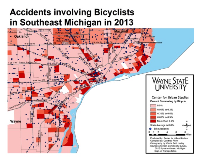
In 2013, there were 1,871 traffic accidents reported to the police that involved a bicycle in the seven counties that comprise Southeast Michigan. Here, the locations of these accidents are overlaid with previously displayed data about bicycle ridership rates for commuting that was reported to the Census Bureau. There is some overlap between high bicycle commuting and accidents, particularly in Royal Oak and Ann Arbor, but accidents are widely distributed across the populated areas of the metro area.
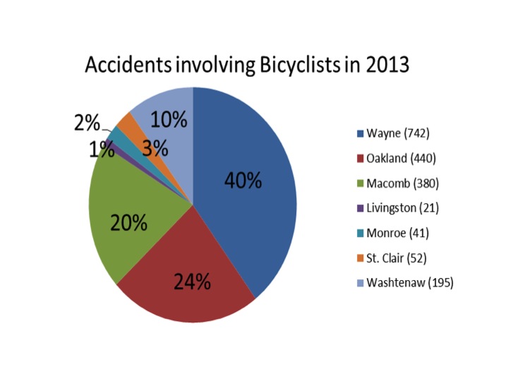
More accidents (40 percent) were in Wayne County than in the Southeast Michigan suburban counties. Wayne County and Detroit have a larger number of bicyclists on the road than many of the other locations in the region. Nearly a third (33.1 percent) of the Wayne County accidents took place in Detroit. Ann Arbor, in Washtenaw County, also has a large biking community. It was the site of two thirds of the accidents in the county; overall these accidents were 10 percent of the region’s total. Oakland and Macomb counties had the majority of their accidents in the areas of their counties that were closest to Detroit, while Monroe, Livingston and St. Clair counties experienced most of their bicycle accidents in their larger communities.
There was an increase in bicycle accidents when the weather was warmest. Just less than a third (31 percent) occurred in July and August combined. There was a decrease in accidents on weekends (average=211) vs. weekdays (average=290).
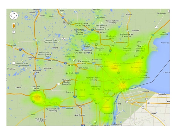
Our second map displays the same accident information, but does so by creating a “heat map” that displays the data by increasing the hue where there is a higher concentration of accidents. This map demonstrates that areas with a high number of cyclists, such as Ann Arbor and Midtown Detroit, have higher rates of accidents, which is shown in the yellow and red hues on the map. The map also highlights a second set of areas where there are a high number of accidents. It shows that some of the Suburban areas just outside Detroit are dangerous places for bikers to navigate safely – areas such as Ferndale and Eastpointe.
The third map shows Detroit and its immediate vicinity, allowing us to look more closely at the pattern of accidents. With the addition of information about state-regulated roads, we can see that major thoroughfares create safety hazards for cyclists, and these corridors are particularly problematic in the suburbs. The corridors of Woodward Avenue, Mound Road, Gratiot Avenue, Grand River Avenue, Telegraph Road, 8 Mile Road , Ford Road, Michigan Avenue and Fort Street each have accident clusters just beyond the Detroit city limits. The same pattern of accidents along thoroughfares is evident in Detroit proper. Again, we see that areas that connect two biking communities provide high hazards. Woodward and Grand Boulevard, which connect high-biking areas of Highland Park and Hamtramck to high-biking Midtown provides one example, but there are other areas throughout the city and its near suburbs that follow this pattern. These patterns indicate a need for cycling infrastructure that connect locations to improve safety and increase cycling.