A number of national and international environmental incidents in the early 1980s led to the federal Emergency Planning and Community Right-to-Know Act (EPCRA) in 1986. EPCRA mandates all facilities that handle or produce at least 10,000 pounds of any of 650 chemicals known to be harmful to humans or the environment annually report any releases into the environment This information is made available to the public via the Toxic Release Inventory (TRI).
In this post we will examine releases of two of those 650 chemicals – lead and lead-based compounds. For those interested in learning the effects of lead please click here.
Below is a map showing the location of the 2012 releases of lead and lead-based compounds in the Southeast Michigan area.
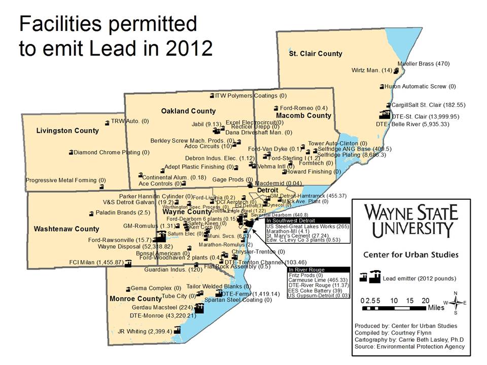
In Southeast Michigan, 38 of 87 reporting facilities indicated they had no on-site releases into the land, water or air (These are 0’s on the map). The largest releases Southeast Michigan was Wayne Disposal, in Belleville, which reported more than 52,000 pounds of lead or lead-based compounds. How much of this stays in landfills versus gets released by air or water is not reported. This facility is a landfill that receives toxic waste, including being the only recipient of polychlorinated byphenols (PCBs) in the State of Michigan. In addition to skilled waste handlers, power generation is another top contributor to lead releases, with DTE and other generating plants along rivers and lakes releasing large quantities of lead and lead-based compounds, well over 60,000 pounds.
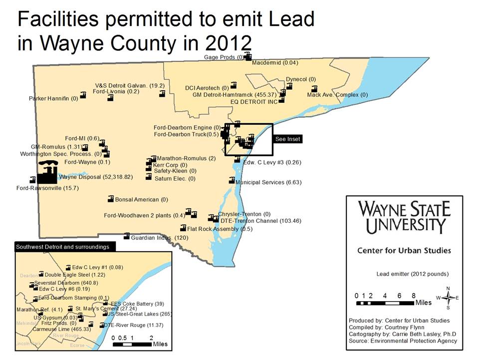
Wayne Disposal, the region’s largest reporter of releases lead and lead-based-compounds (52,318 pounds), is located in Wayne County, along with about 35 other facilities. It may be reasonable to assume that the vast majority of this went into their landfill, but no data is provided about the specifics beyond the amounts. There are a total of 36 facilities reporting in Wayne County; altogether these facilities reported releasing a total of 54,366.91 pounds in 2012, as shown on the map below. There is a concentration of facilities reporting releases of lead and lead-based-compound in and near Southwest Detroit. However, the largest reported releases in Detroit were from the GM Detroit-Hamtramck Assembly Plant, which is bisected by the southern border of Hamtramck and Detroit.
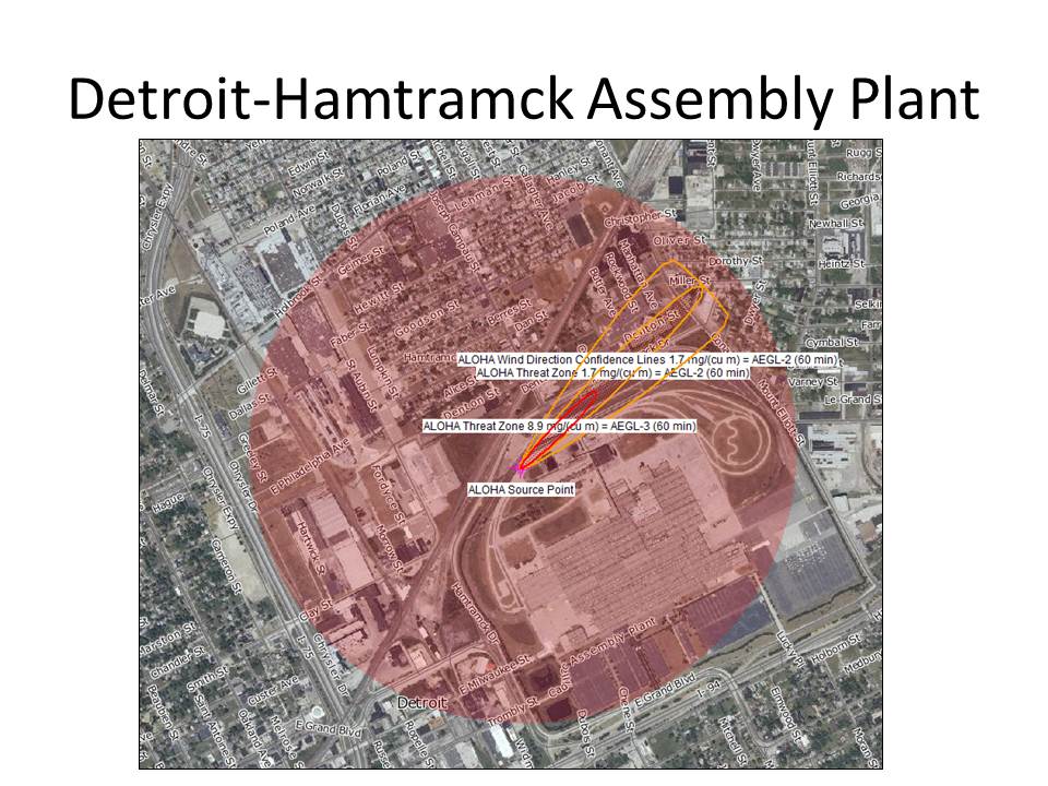
Releasing just over 455 pounds of lead-based compounds into the air in 2012, the GM Detroit-Hamtramck Assembly Plant is large, as well as near areas of dense settlement. Using software developed by the U.S. Military and adapted for use by the Environmental Protection Agency, we used dominant weather conditions to determine the approximate area in which these compounds, emitted from on-site stacks, may fall. The result is shown on the map below. The tri-color cone is the area most likely to be impacted because of dominant weather conditions (Winds 10 mph, 58oF, partly cloudy). The circle includes areas impacted by changing wind directions. Additional clouds, wind or precipitation could create a wider pattern of impact. Within the circle, live 5,963 people in 1,997 housing units (2010 Census). There are also three schools (Hanley, Holbrook and Oakland International) and one park with athletic facilities (Veterans in Hamtramck). Oakland International Academy falls under the cone of dominant exposure.
This set of estimates are based on a centroid in the northern area of the site, near cooling towers, but the results could vary depending on the specific location on the site where releases occur. There appear to be several large stacks and many small stacks on the site. Some stacks are located further east on the site, which would yield estimates that cover more residential areas in Detroit.
Releasing just more than 455 pounds of lead-based compounds in 2012, the GM Detroit-Hamtramck Assembly Plant is large, as well as near areas of dense settlement. Using software developed by the U.S. Military and adapted for use by the Environmental Protection Agency, we used dominant weather conditions to determine the approximate area in which these compounds, emitted from on-site stacks, may fall. The result is shown on the map below. The tri-color cone is the area most likely to be impacted because of dominant weather conditions (Winds 10 mph, 58oF, partly cloudy). The circle includes areas impacted by changing wind directions. Additional clouds, wind or precipitation could create a wider pattern of impact. Within the circle, live 5,963 people in 1,997 housing units (2010 Census). There are also three schools (Hanley, Holbrook and Oakland International) and one park with athletic facilities (Veterans in Hamtramck). Oakland International Academy falls under the cone of dominant exposure.
NOTE:The software Aloha and Marplot were used to used to estimate the spread of lead pollution in the area. In Aloha lead pollution can not be estimated so mercury was used as a proxy. The weight of lead per cubic inch is 0.39 lbs; the weight of mercury is 0.49 lbs. per cubic inch.
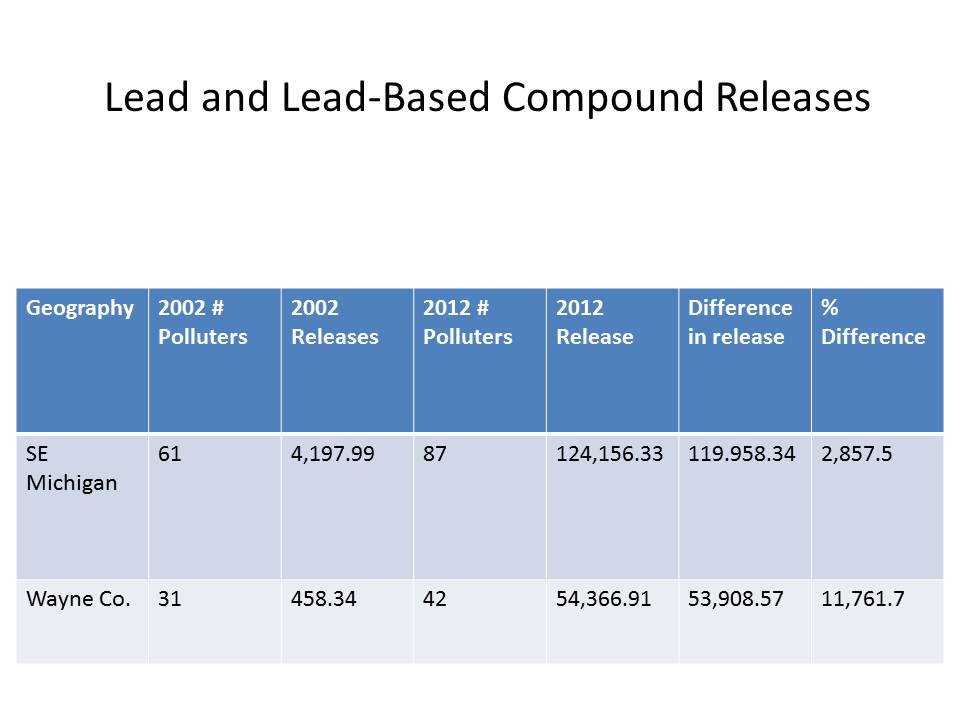
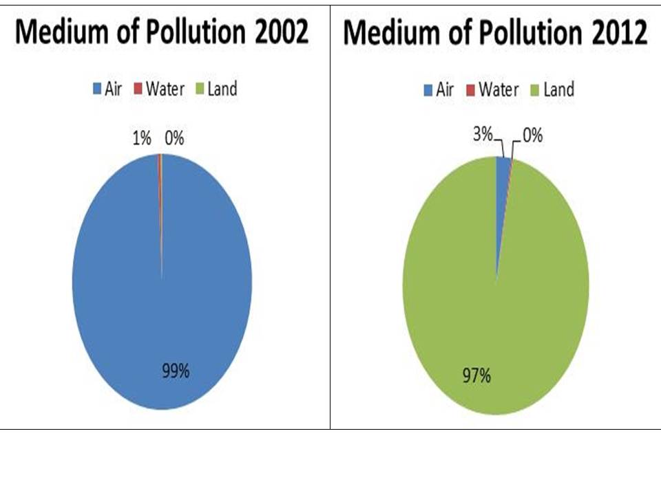
To better understand the increase in lead pollution, we examined how lead was released into Wayne County. TRI documents releases into all mediums of the environment, breaking them down into details. Aggregating the categories into the three major environmental mediums – air, water and land, we can see that which methods of lead pollution has changed dramatically over the decade. In 2002, air pollution was the predominant medium, accounting for 99 percent of all lead pollution (455 pounds in total from stack releases and fugitive emissions). Since 2002, this amount has increased in aggregate (1,453 pounds in 2012, a 319 percent increase); however, the proportion of reported lead releases into the air has decreased in relation to the total, from 99 percent in 2002 to 3 percent in 2012.
The dramatic increase in reported lead releases has come from land releases – or that stored in landfills or otherwise held on site. In 2012, 96 percent of the total emissions for the region came from a single facility – Wayne Disposal, a toxic waste facility located on the Wayne/Washtenaw border near Belleville. As explained earlier, a facility must report if it handles more than 10,000 pounds of a toxic chemical, whether or not the facility releases the chemical or handles it without a release. Opened in 1997, Wayne Disposal was not handling enough lead or lead-based compounds in 2002 to require TRI reporting. By 2004, Wayne Disposal was handling enough to trigger reporting requirements. Eight years later, it is the largest single reporter in the region, reporting more than 52,000 pounds of lead or lead-based compounds. In future posts we plan to investigate the sources of the lead maintained at the facility. In general, we expect to find that most of the lead is from lead-based paint that is part of demolition debris from older houses in the metropolitan area.