The ongoing demographic changes in urban and suburban communities present a challenging task for cultural organizations. Unlike more dynamic creative industries (media firms, telecommunications, law and other consulting firms) that often have the capacity to choose their location, most cultural organizations rely heavily on fixed capital that ties them to their historic locations. The majority of long-standing cultural organizations (history and natural history museums, opera, ballet, symphony, art museums) were established in certain geographic locations (mostly urban centers) by elites from former generations at the time of the Industrial Revolution or during periods or urban prosperity and growth. In post-industrial cities, such as Cleveland, Pittsburgh, and Detroit, many of these institutions face severe survival and sustainability pressures due to the overall economic decline, reduction in the attendance rates, increased competition for funding with other organizations, and the aging of their core audiences and supporters. The problem of audience decline is particularly salient in areas with high population diversity, as well as areas that lack proper infrastructure to provide access to cultural resources for traditionally underserved populations.
In response to these issues, the Center for Urban Studies has been conducting research on exploring the locational patterns of cultural organizations in Southeast Michigan. The study is being conducted in collaboration with the Wayne State University’s Assistant Professor of Political Science Alisa Moldavanova, who studies nonprofit organizational sustainability. This study examined the locational patterns of 216 cultural organizations in Southeast Michigan in relation to the social and demographic profile of their communities. The goal is to holistically explore the existing geographical, institutional, and social barriers limiting access to cultural organizations, analyze the public accessibility of these institutions, and develop recommendations regarding improving access to cultural organizations.
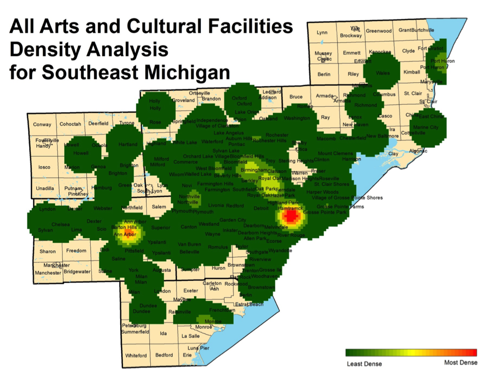
As the first step in this study, we have explored the density of cultural organizations’ locations in the seven-county region of Southeast Michigan. Our analysis shows that different types of cultural institutions are unevenly distributed in this geographic area, as seen in the map below. There are areas of cultural districts (high density of particular types of organizations and the overall presence of the sector), and cultural deserts (low density of particular types of organizations and the sector). We see a high concentration of arts and cultural institutions in Detroit, Ann Arbor and near the Bloomfield Hills area. The opposite is true for many of the rural communities in the region and even suburbs bordering the high-density arts and cultural areas like Detroit and Ann Arbor. Newer organizations in this study appeared to select locations with access to donors (and where donors had relocated as the city expanded), creating mini-districts in recent suburbs such as Bloomfield Hills in Oakland County (established 1932), Rochester Hills in Oakland County (established 1984), and Northville in Wayne County (established 1955). This suggests that, as cities and regions have expanded, the original organizational location may no longer serve the institution in the same manner it once did, and may fail to adequately reflect current and future needs of local communities.
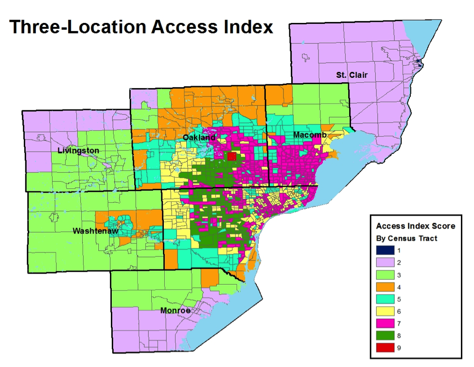
As the second step in this study, we have been constructing an index of access to cultural organizations that takes into account admissions policy, the physical characteristics of a location (i.e. travel distance), and the availability of, and access to, transportation. So far, we have applied the index to three selected organizations – the Detroit Institute of Arts, Cranbrook Art Museum and the University of Michigan Art Museum. We analyzed the levels of access to these institutions by different CENSUS tracts. When used in combination with community socio-demographic characteristics, this index, which is displayed in the map below, reveals that certain groups of the population are at a greater disadvantage in terms of their access to cultural amenities. In particular, areas of the lowest access are the most rural, have the greatest number of people with less than Bachelor’s degree, the greatest number of unemployed people, and the lowest median household income. On the contrary, areas with the highest access tend to be urban and suburban. Some have the highest median household income, the lowest percent of unemployment, the least percentage of people in poverty, and the greatest number of seniors, while some of the older urban areas, still have high access because of their proximity to the historic cultural centers. These areas tend to have lower socio economic indicators. The access index, therefore, reveals that, due to access barriers, some organizations may be underutilizing an important community resource – diverse audience, while others like the DIA still provide access to diverse populations. Interestingly, Western Wayne County and south Central Oakland County enjoy relatively high access because of their centrality relative to the three institutions studies here.
In the map below, we see that the areas with the lowest access to the three art museums
(Detroit Institute of Arts, Cranbrook Art Museum and the University of Michigan Art Museum), which have an index score of 2 and are colored in purple, are located in the more rural edges of the region in St. Clair, Livingston, and Monroe counties. One area in the region has the highest access score (9, colored red), and that is the area around Bloomfield Hills. Residents in this area have one the highest median incomes in the region.