Throughout Southeastern Michigan the City of Detroit had the highest number of Census tracts with the lowest access to food sources, according to 2015 data from the U.S. Department of Agriculture (USDA). For the purpose of this post, low income is defined as Census tracts with a poverty rate of 20 percent of higher or with a median family income less than 80 percent of median family income for the state or metropolitan area. Areas with low access to food are identified as Census tracts having 33 percent of the population living within a certain mileage from a grocery store. In this post these areas are identified by either being a half-mile or mile from a grocery store in an urban area and 10 miles in a rural area (these differences are identified in each map below). According to the USDA, none of the counties and/or Census tracts in Southeastern Michigan are identified as rural, so the 10 mile rural identifier will not be used in this post.
Half-mile Mile
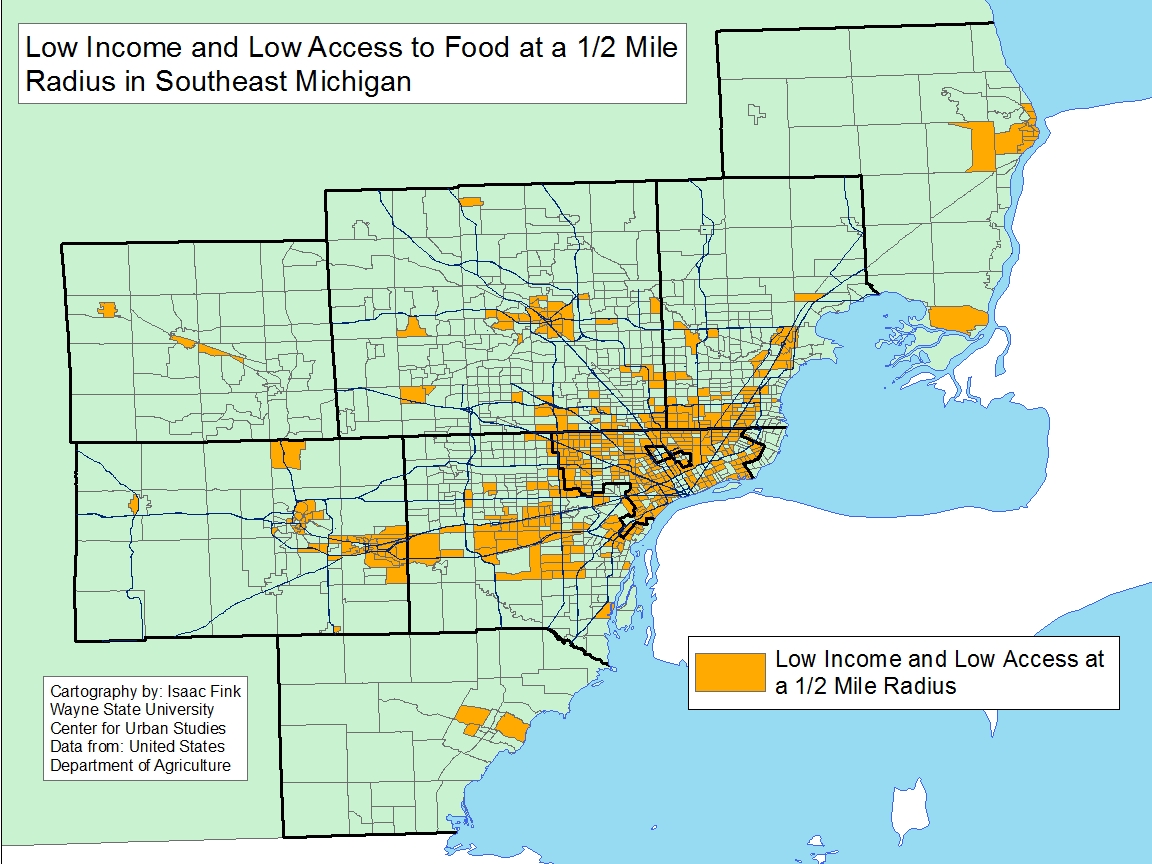
When examining the Southeastern Michigan region for the number of Census tracts with low-income families and low access to food sources within a half-mile majority of the City of Detroit is highlighted in the map below, in addition to Hamtramck and Highland Park. There were also several Census tracts just outside the border of Detroit, in areas including Warren, Eastpointe, Dearborn, Hazel Park and Southfield, that had low incomes and low access to reliable food sources. While there were several Census tracts in every one of the seven counties in the Southeastern Michigan region, it was Wayne County that had the had the highest number of residents with low incomes and low access to grocery stores within a half-mile of residents’ homes.
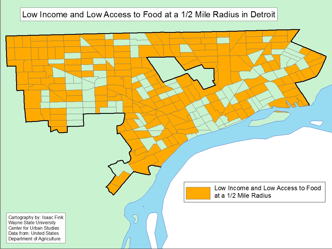
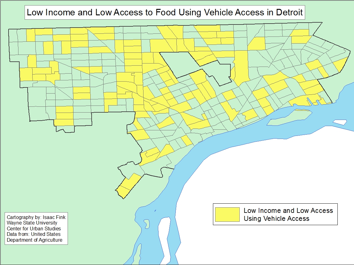
A closer look at just the Census tracts in the City of Detroit show that there were only a select number of pockets in the City that were not considered low income and also had access to a grocery store closer than a half-mile. One such area that stands out is the downtown area. Other areas include the Denby, Cody Rouge and West Village neighborhoods.
In Washtenaw County, it was the Ann Arbor/Ypsilanti area that had the highest number of Census tracts with low-income families not having access to grocery stores and in Oakland County, beyond those Census tracts that border Detroit, it was the Pontiac that had the most number of low-income residents with low access to food options. In the less densely populated counties in the region (Monroe, St. Clair, Livingston) there was an average of about three Census tracts with a poverty rate of 20 percent of higher or with a median family income less than 80 percent of median family income and access to a grocery store more than a half-mile away.
One Mile
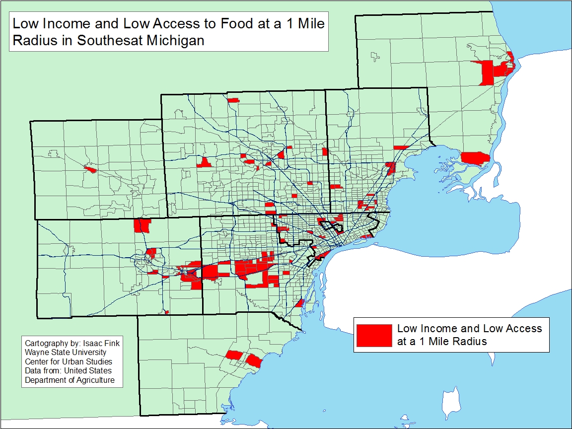
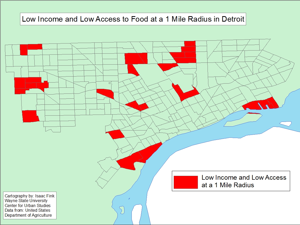
When the radius was expanded to one mile, the number of Census tracts without access to grocery stores dramatically decreased. The most notable decrease in the region was in the City of Detroit. In the maps below there are only about 20 Census tracts in the City of Detroit with a poverty rate of 20 percent of higher or with a median family income less than 80 percent of median family income and access to a grocery store more than a mile away. In the maps above, which depict access within a half-mile, nearly the entire City is highlighted for low income and low access. A notable difference due to access between a half-mile and mile can also be seen in the Ypsilanti/Ann Arbor area.
Throughout Livingston, Monroe and St. Clair counties there was a minimum decrease in the number of Census tracts with a poverty rate of 20 percent of higher or with a median family income less than 80 percent of median family income and access to a grocery store more than a half-mile away.
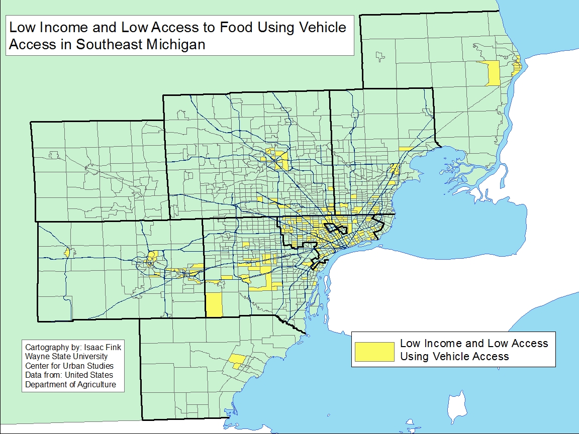
Low Income and Low Vehicle Access
The maps below identify low-income Census tracts where more than 100 housing units did not have a vehicle and were more than a half-mile from the nearest grocery store. When applying these variables we see there was an overall fewer number of Census tracts without access than when only looking at access, despite transportation accessibility. This was particularly true throughout Wayne County and in Census tracts just north of Wayne County. In Detroit, the highest concentration of Census tracts with more than 100 housing units not having a vehicle and that were more than a half-mile from the nearest grocery store were those on the west side of the City along Livernois Avenue.
In examining the data provided by the USDA, we see that regionally it was the City of Detroit, its inner-ring suburbs that had the highest number of low-income families with among the lowest access to food due to the location of grocery stores in 2015. To help support access to grocery stores, a robust public transportation network could be one solution, particularly in Detroit and its surrounding cities. Additionally, it is also important to understand the impact low incomes have on families when it comes to accessing healthy foods. While grocery stores may be within a half-mile or mile from a home, once an individual reaches a grocery store the chances of them purchasing fresh, non-processed foods may not be as high due to cost, and quite possibly access within the store. To support access to fresh foods in urban areas like the City of Detroit the Detroit Food Justice Task Force recommends policies that allow for more support of neighborhood famers markets and small businesses and research that identifies the food needs of neighborhoods throughout the City.