The new Congressional district maps for Michigan have not been finalized, but drafts are in the works, and districts are certain to change.
First off, the process in which Congressional and State House and State Senate districts are drawn has changed. Prior to 2018, the Michigan State Legislature redrew districts using population and demographic data from the US Census Bureau. This process was inherently political and lead to gerrymandered districts, as we highlighted in one of our earliest posts.
Come 2018, a change was mandated when Michigan voters approved the creation of the Michigan Independent Citizens Redistricting Commission. This Commission, which has been regularly meeting and taking public input over the last several months, is led by a bi-partisan citizen group. The MICRC is composed of four Democrats, four Republicans and five independents.
Another change regarding the mapping of Congressional districts was then announced in 2020—Michigan would lose a seat in the US House Representatives-dropping from 14 to 13—due to a shift in population. This is the fifth time in a row Michigan has lost a Congressional seat. This is because that other states have gained substantially more population than Michigan.
In addition to Michigan losing a Congressional seat so did California, Illinois, Ohio, Pennsylvania, New York and West Virginia. The states that gained a single seat are: Colorado, Oregon, Montana, North Carolina and Florida. Texas gained two Congressional seats.
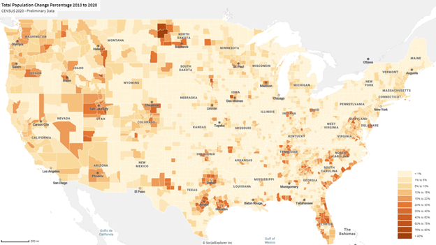
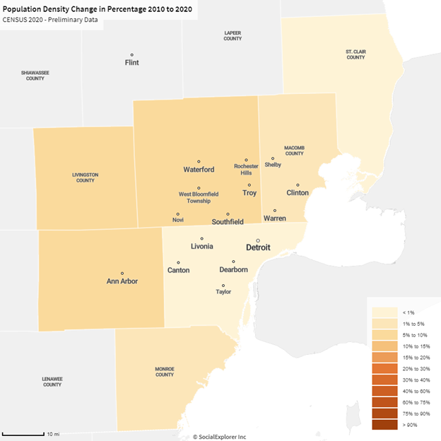
The map below shows the percent change in population between 2010 and 2020, according to the Census Bureau. And, while the map doesn’t highlight a significant population loss for Michigan it does show how other areas throughout the country are experiencing more rapid population growth while we remain increased only slightly.
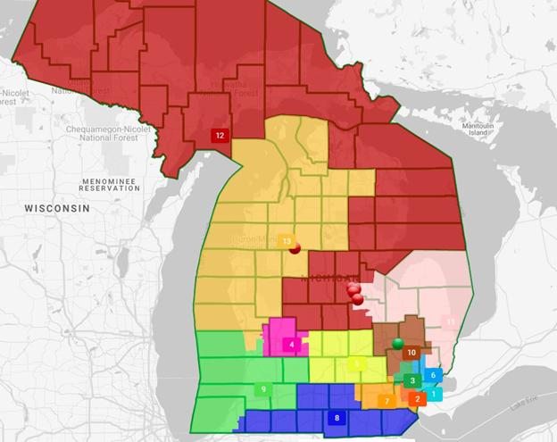
Current MICRC proposals that affect Southeastern Michigan include Oakland County being included in five Congressional districts, as opposed to the four it is currently included in, Wayne County in three or four districts, as opposed to the two it is currently located in, and Macomb County being stretched amongst three or four districts, as opposed to the two it is currently in. All of these are still proposed, and non-finalized, maps of course. But this means shakeups for current members of Michigan’s Congressional Delegation. For example, a proposed map shows that current Congressman Andy Levin and current Congresswoman Brenda Lawrence could be living in the same district. Another proposed shift is for the 10th District, which could include parts of Oakland, Macomb and Genesee counties. The current Congress members who represent parts of that new proposed district are Elissa Slotkin (D-Holly), Dan Kildee (D-Flint) and Lisa McClain (R-Bruce Township). If that proposal were to move forward those current members of Congress could all be vying against each other in the election process.
According to the criteria approved by voters when they approved the MICRC, new district maps must:
· Comply with the U.S. Voting Rights Act and be of equal population;
· Be geographically contiguous;
· Reflect the state’s diverse population and communities of interest;
· Not provide a disproportionate advantage to any political party;
· Not favor or disfavor an incumbent;
· Respect county/municipal borders;
· Be reasonably compact.
While Michigan’s population has changed minimally, there still have been population shifts internally, which will also impact the new Congressional districts.
For example, St. Clair County lost 1.6 percent of its population and Wayne County lost 1.5 percent of its population between 2010 and 2020, while Washtenaw County experienced about an 8 percent population increase, and Livingston County experienced about a 7.5 percent population increase. While Congressional seats don’t include just one county, understanding where the State’s population has shifted does help shed light on how the districts may shift.
The final Congressional District maps will go into play for the 2022 election. Three maps for final consideration must be chosen by the MICRC on Oct. 1, 2021. To leave a comment on the proposed maps or the process visit here.