Park Land is Plentiful in Southeastern Michigan

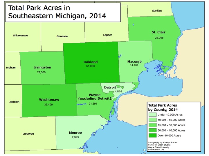
In Southeastern Michigan there are more than 2,300 parks which are owned and operated by either the federal government, State of Michigan, a local municipality, the Huron Clinton Metroparks Authority or a private entity. The footprint of these parks covers more than 214,000 acres and much of these parks are concentrated in the more heavily populated areas of Southeastern Michigan, such as Wayne, Oakland and Macomb counties. For example, in the City of Detroit there are 359 total parks, which range in size, type (passive, active, trails, etc.) and ownership (city, state, private).  Parks are viewed as an essential service because they increase economic value, provide health and environmental benefits and create an aspect of community, allowing for greater socialization. Furthermore, understanding how accessible parks and recreation amenities are can help communities prioritize improvements that serve more people.

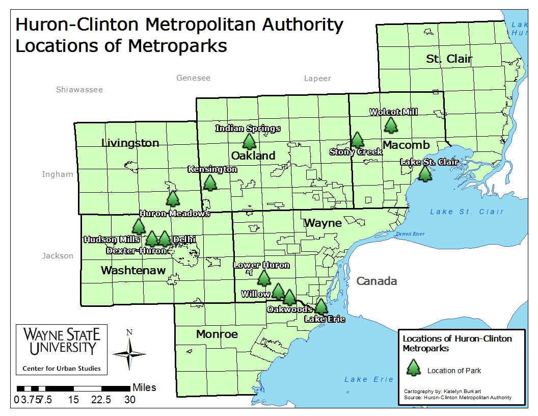
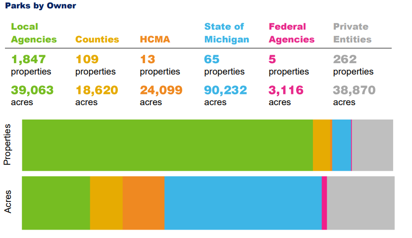
In Southeastern Michigan 1,847 of the parks in the region, or 80 percent, are owned and operated by local municipalities. For example, of the 359 parks in Detroit about 350 are owned and operated by the City itself, the others are owned and operated by the Michigan Department of Natural Resources or private entities. Private entities in the region own and operate the second highest number of parks in the region, followed by counties. The way in which counties prioritize parks in the region varies greatly. For example, in Macomb County there are only two county parks—Freedom Hill, which serves as an entertainment center, and the Macomb Orchard Trail, which is a 26 mile long multiuse path that is overseen by a board comprised of a county representative and one person from each community that also pays into the system. In Oakland County there are 13 parks and in Washtenaw County there are well over 20 different parks, many of which are nature preserves.

Public parks are largely funded by public monies and each municipality’s priorities are reflected in how their dollars are spent. So, in the case of Washtenaw and Oakland counties, for example, we see that the counties themselves place a higher priority on access to parks. The emphasis on parks and recreation opportunities in communities can not only be seen by how the general fund dollars are allocated to such amenities, but also by if there are additional taxes voted on by residents to further increase parks and recreation amenities and access to them.

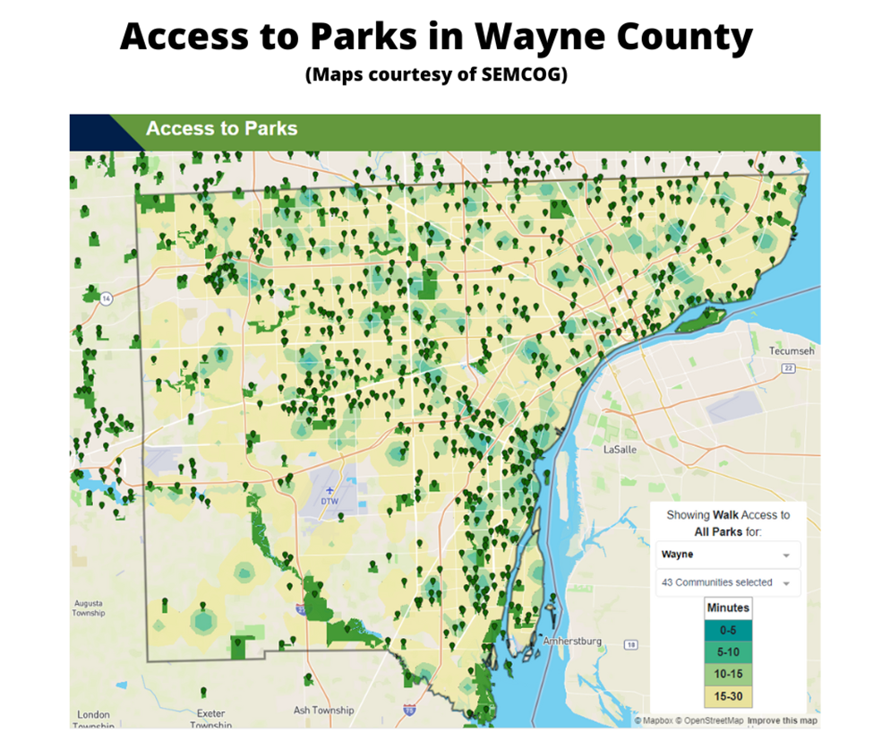
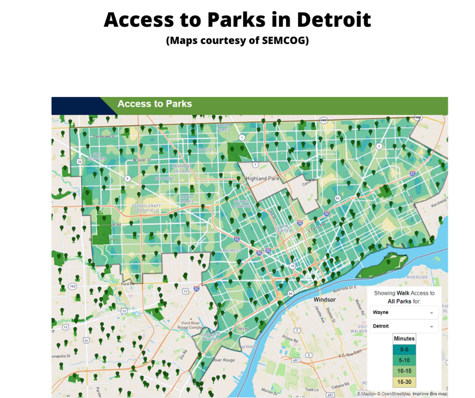
While funding allocations to parks differ from one county, and community, to the next, we do know that access to parks in the region is easily attainable for most. As noted, majority of the parks are concentrated in more heavily populated areas, but according to the Southeastern Michigan Council of Government’s (SEMCOG) 2019 Parks and Recreation Master Plan, parks and recreation opportunities are accessible within a 10-minute drive for nearly every household in the region. Additionally, according to the study, a 10-minute bike ride provides access to parks for 89 percent of households in the region. The study does show that for 42 percent of households in the region access to parks within 10 minutes of walking or use public transportation is not attaintable, posing a barrier of access to those who may not have a reliable use of their transportation. The lack of a strong public transportation system in the region does prove to be problematic for those who want/need reliable access to parks, especially the region’s largest parks. Since larger parks are located in less populated areas those without reliable transportation of their own, who may rely on public transportation, will have greater difficulty in reaching the larger parks. SEMCOG’s Access to Core Services report state that 7 percent of all households and 13 percent of transit-dependent households are within a 30-minute transit trip to a park greater than 200 acres in size.

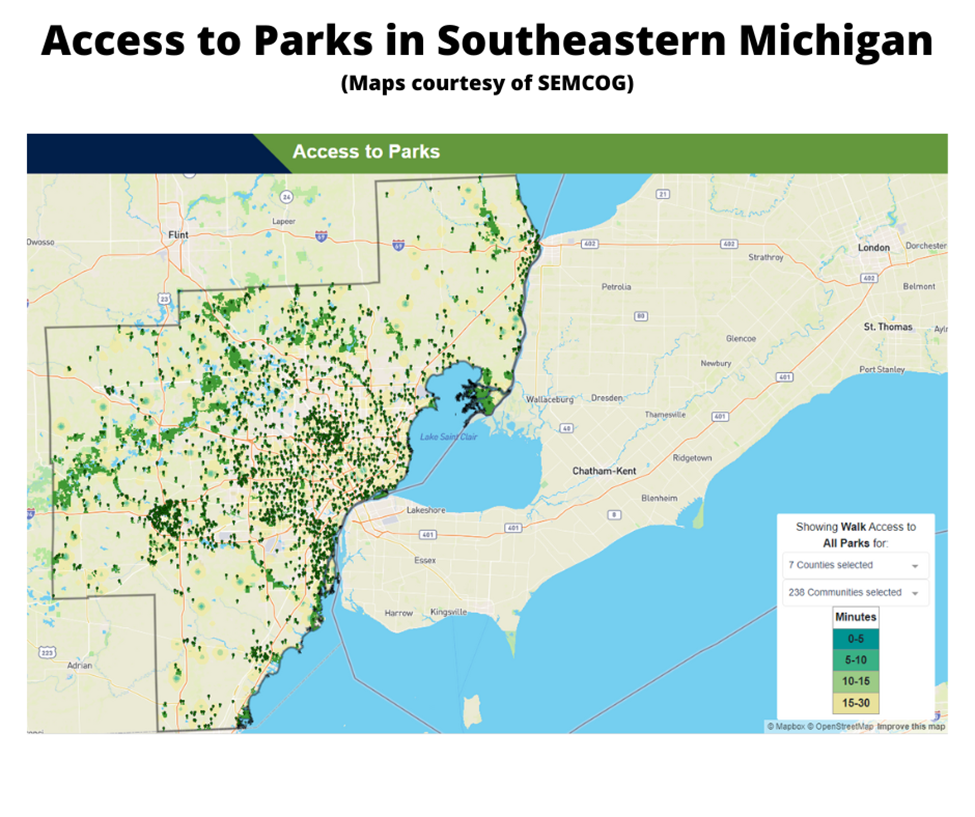
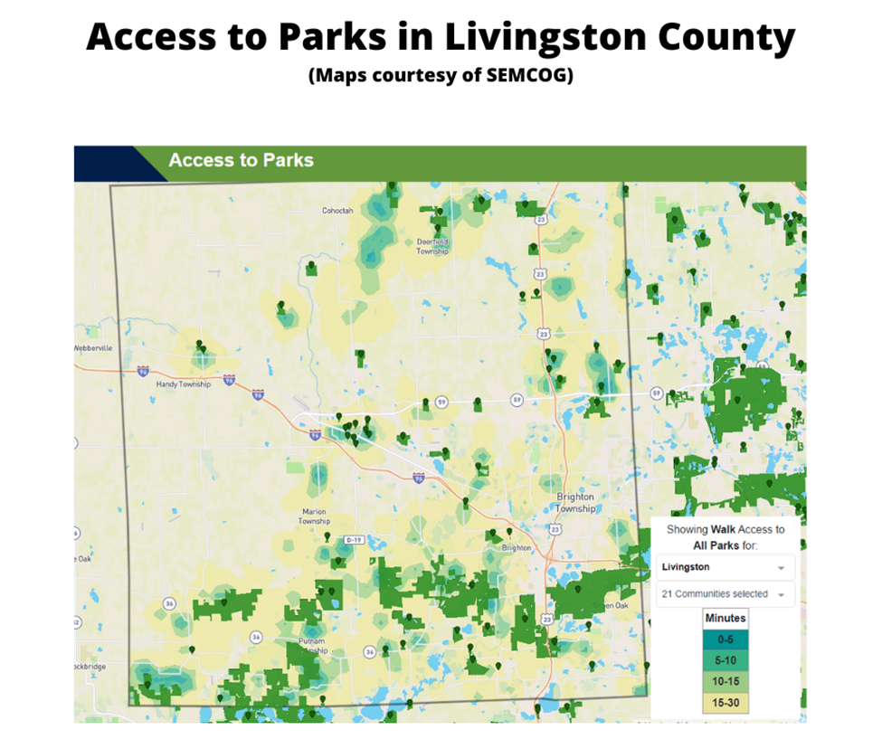
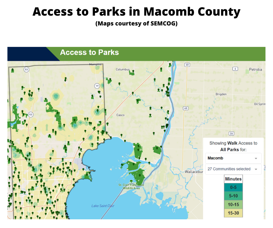
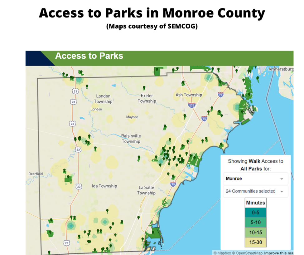
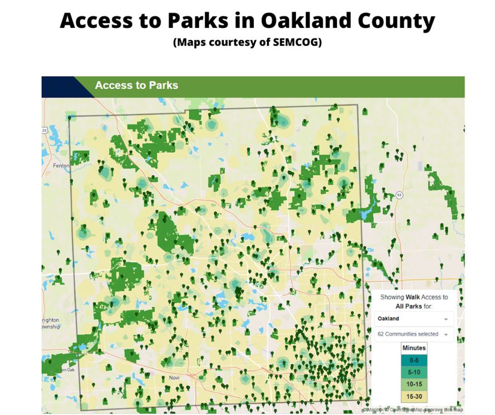
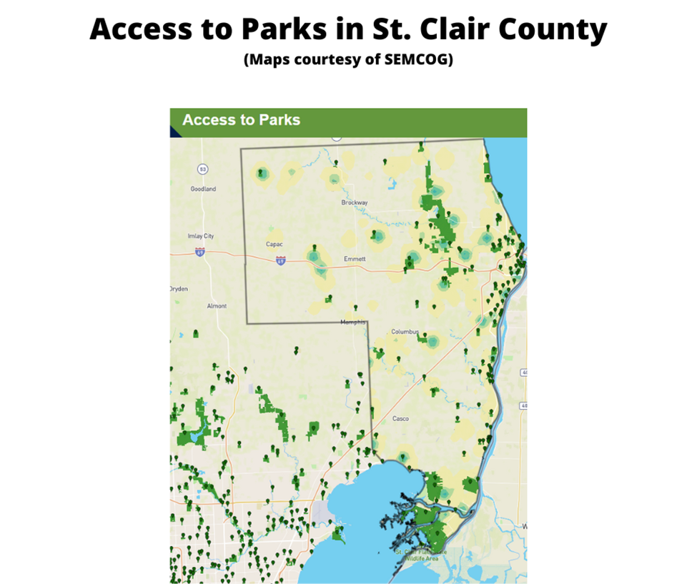
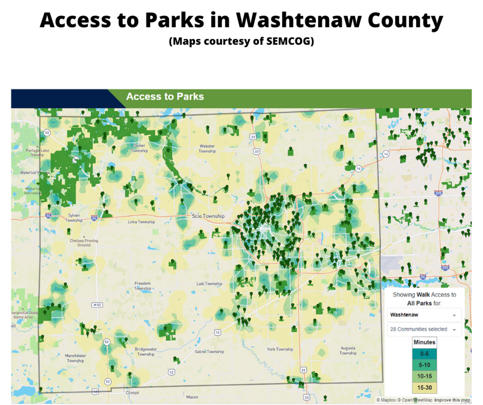
The maps below highlight where parks are located in the region.

As noted, parks are viewed as an essential amenity within a community. However, funding to maintain and improve parks and recreation amenities is also vital to ensure such access. While we know majority of the region can access parks and recreation opportunities currently, we will further look into some of the funding structures that allow for such access in a later post and evaluate their long-term viability. We will also look deeper into the access of parks as it relates to the socioeconomic makeups of communities in Southeastern Michigan.

Monroe, St. Clair Counties Rank Highest for Green Infrastructure; Majority is Agricultural Land

In Southeastern Michigan there was about 180,000 acres of green infrastructure in 2014, according to the Southeastern Michigan Council of Governments (SEMCOG), and the regional planning agency is looking to improve and grow that number. This green infrastructure represents both natural ecosystems (wetlands, forests and parks), agricultural land and constructed versions, such as community gardens and bioswales. Both Monroe and St. Clair counties had the highest percentage of total green infrastructure in 2014 at 67 percent. Wayne County, both including and excluding Detroit, had the lowest percentage of green infrastructure. Excluding Detroit, Wayne County was made up of 32 percent of green infrastructure; including Detroit Wayne County was made up of 30 percent green infrastructure. In general, one can think of green infrastructure as the inverse of developed land, where houses, businesses, roads and other infrastructure exists.

Of this overall green infrastructure it is important to identify what it is comprised of. Below we will see how the tree canopy varies from county to county and how these variations are affected by the presence of parks and agricultural land.

The data provided for this post was found in SEMCOG’s 2014 Green Infrastructure Vision document.

Metro-Detroit Green Infrastructure

In total, Oakland County had the highest percentage of overall tree canopy at 44 percent; the county’s tree canopy made up 86 percent of its total green infrastructure. Oakland and Livingston counties were the only two in the region that had a tree canopy above the American Forest’s overall standard of 40 percent. The American Forest is the country’s oldest conservation non-profit, and SEMCOG bases its green infrastructure goals on their standards.

The county with the lowest overall tree canopy was Monroe; it had a tree canopy of 20 percent. This 20 percent of total tree canopy made up 28 percent of its total green infrastructure. This is largely because of the greater portion of land devoted to agriculture, as discussed below.

The city of Detroit had a total tree canopy of 16 percent, which is below American Forest’s standard for tree coverage in an urban area. Nevertheless this represents 85 percent of Detroit’s green infrastructure. American Forest calls for a 25 percent tree canopy coverage in an urban area. In a suburban residential the organization’s standard is 50 percent, and in a central business district that standard is 15 percent.

Metro-Detroit Tree Canopy

Metro-Detroit Tree Canopy and Green Infrastructure

While tree coverage is an important aspect of green infrastructure, it is not the only thing that can make a community “more green.” As discussed above, Monroe County had the highest percentage of overall green infrastructure yet the lowest percentage of tree canopy coverage. As shown below, this is, in part, because there was more than 123,000 acres of agricultural land in Monroe County in 2014. Monroe County had the highest amount of agricultural land in 2014 in the region followed by St. Clair County, which had about 107,000 acres of agricultural land. St. Clair County, like Monroe County, was made up of 67 percent green infrastructure. According to SEMCOG, Monroe County ranks seventh in the state in the total number of acres of vegetables (6,707) and corn, soy and wheat (169,792). St. Clair County ranked sixth in the state in the number of farms producing organic products and eighth in state for the total number of acres of soybeans it produced in 2014 (64,224).

According to SEMCOG, agricultural land is defined as “rural land used with the growing of food as the primary function, but can also provide ecological benefits.” SEMCOG classified Detroit as having 0 acres of agriculture, but this does not include the number of community gardens, which have been growing in the city through individual and organizational efforts.

While Detroit had 0 acres of agriculture land, Wayne County had 8,726 acres of agricultural land, which was the smallest amount in the region.

Metro-Detroit Agriculture Land

For total acreage of agricultural land in the region, Oakland County had amongst the smallest amount of coverage in the region but for wetland coverage it had the greatest amount. Oakland County had 77,000 acres of wetland in 2014. St. Clair (62,000 acres), Livingston (60,000) and Washtenaw (53,000) counties all had more wetland coverage than Wayne County. However, the 41,900 acres of wetland coverage in Wayne County was nearly five times the amount of agricultural land in the county. Additionally, of those 41,900 acres, 100 were located in Detroit.

Monroe County had the least amount of wetland coverage at 20,000, which is about 100,000 less acreage than it had of agricultural land.

Metro-Detroit Wetlands

Another factor into the total amount of green infrastructure present in a county is park land, which includes city, country, metro and state parks. Oakland County had the highest amount of park acreage at 61,053. Oakland County is home to five state park/recreation areas, three metroparks, 13 county parks and numerous local parks at the municipal level. Washtenaw County had the second highest acreage of park coverage at 33,499 acres, which was nearly half of Oakland County’s coverage. Like Oakland County, Washtenaw County is home to three metroparks and 13 county parks. Washtenaw County also has 20 nature preserves, numerous parks at the local level and nine state park/recreation areas.

Wayne County had about 26,000 acres of total park acreage, about 5,000 of which was located in Detroit. Belle Isle made up nearly a fifth of Detroit’s park acreage; it is 982 acres.

Metro-Detroit Parks

The amount of green infrastructure established in a community and a region is important because it can not only serve as a catalyst for economic growth but also because it serves as the base for ensuring citizens have access to clean water and air, fresh food and amenities that promote healthy and sustainable lifestyles. There is a recognition that additional green infrastructure is needed in Southeastern Michigan, which is why SEMCOG has created a green infrastructure vision. This vision aims to benchmark the current green infrastructure in the region and then identify policies that will allow for stronger and more connected infrastructure networks, more accessibility and cleaner air and water quality.

Part I: Metro-Detroit’s shift toward regionalism starts with Metroparks, speeds up with economic downturn

Regionalism in Southeastern Michigan began to take shape in the 1930s, but it was not until the financial decline of Detroit and the broader region, that multi-jurisdictional authorities truly began to take over an array of services.
The oldest extant regional entity formed in Southeastern Michigan is the Huron-Clinton Metropolitan Authority. Enabled by the Michigan State Legislature in 1939 by Public Act No. 147, the residents of Livingston, Macomb, Oakland, Wayne and Washtenaw counties approved the authority the following year. In 1942, funding for the parks became available, according to the authority’s history. Since that time the authority has grown to oversee 13 metroparks, which together encompass more than 25,000 acres. The Huron-Clinton Metropolitan Authority is governed by a seven-member board; two members are appointed by the governor and the other five are appointed by the Board of Commissioners of the member counties. Currently, all of the metroparks are supported by a 0.2146 mill levy on the residents of Livingston, Macomb, Oakland, Wayne and Washtenaw counties. This levy is equivalent to $10.73 for a home valued at $100,000 ($50,000 taxable value).

Metroparks

Southeast Michigan took an additional step toward regional cooperation more than 25 years later (1968) by establishing the Southeastern Michigan Council of Governments (SEMCOG). This regional planning entity, along with other regional planning organizations in the state of Michigan, was authorized by Public Act 281 of 1945.

According to its website, SEMCOG partners with local government entities—ranging from villages to cities to counties to community colleges—to better improve the area’s waterways, transportation systems and economic vitality. In addition, according to the Clean Air Act and the Water Pollution Control Act, SEMCOG is the region’s planning agency for water and air quality. SEMCOG has also been responsible for the region’s transportation planning.

For SEMCOG, communities choose whether or not they want to be members of regional planning entity. As of the end of 2015 there were 168 different government entities that were SEMCOG members. In Macomb County, Ray Township, along with the townships of Armada, Bruce and Richmond are not SEMCOG members despite their neighbors like Washington and Macomb townships being members. In Oakland County, Pontiac is not a SEMCOG member despite it being surrounded by members.

SEMCOG_members

Despite the existence of regional entities, cooperation among cities and counties in Southeastern Michigan was very limited during much of the 20th century. But Michigan’s economic downturn in the 2000s weakened some of the region’s strongest institutions as they began to face financial problems. One of the first organizations to seek public support through a regional millage was the Detroit Zoo. Once completely owned and operated by the city of Detroit, zoo operations were transferred to the Detroit Zoological Society in 2006. This decision came after the city voted to close it for financial reasons, and the Michigan Legislature promised to provide $4 million to the society for operational aid, according to a 2005 Crain’s Detroit article. Then in 2008, the Michigan Legislature approved Public Act 49, allowing counties to establish a zoological authority and contract for zoological services. The act also gives the counties the authority to levy up to 0.1 mill, with voter approval, for such services. In the same year Public Act 49 was passed (2008), the voters of Wayne, Oakland and Macomb counties were asked to approve a 10-year 0.1 millage, which equals to $5 a year for a home valued at $100,000 (taxable value of $50,000). All three counties approved the millages:

  • Wayne County: 73.15% yes
  • Oakland County: 74.88% yes
  • Macomb County: 66.5% yes

Each of the three counties has its own zoo authority, whose members are appointed by their county commissions or by the county executive office. In Oakland County, the board of commissioners appoints the members; in Macomb County the County Executive makes the appointment recommendation but the Board of Commissioners must confirm; and in Wayne County the executive makes the appointment. Each authority is charged with administering the funds levied from the millage to the Detroit Zoo.

The successful 2008 request for financial support was not the first time the Detroit Zoo sought public assistance through tax dollars, though. In 2000 and 2002 millages were placed on the ballot; Wayne County supported those requests and Oakland County did not, causing them to fail. Macomb County did not participate.

The 2008 millage, which was passed to support operations at the zoo, contributed to 36 percent of the organization’s operational budget in 2014, according to its 2014 financial report. The breakdown of the percentage of millage funds provided to the zoo from each county in 2014 were as follows:

  • Wayne County: 13%
  • Oakland County: 16%
  • Macomb County: 8%
  • (64% funds earned revenue and through fundraising)

Following the regional support for The Detroit Zoo another regional authority was created—this one intended to support Detroit’s Cobo Hall. In September of 2009 the Detroit Regional Convention Facility Authority was formed through passage of Public Act 554 in 2008, which allowed the creation of regional convention facility authorities. This regional authority was formed at a time when the North American International Auto Show threatened to abandon Cobo Hall and Southeast Michigan due to the facility’s size and aging infrastructure, according to a New York Times article. Detroit could no longer financially maintain the convention center at a level that would allow it to host such an international attraction.


When the Detroit Regional Convention Facility Authority was formed, so was a governing body to oversee the regional authority. The governing body is a five-member board with representatives from the City of Detroit, Wayne, Oakland and Macomb counties and an appointee from the Governor’s Office. This body oversees the 30-year capital lease of Cobo Hall (the facility is leased from Detroit), which includes a $299 million expansion/upgrade project. The Detroit Regional Convention Facility Authority receives funding from revenues at Cobo Center as well as support from the state’s Convention Fund.

The Detroit Institute of Arts (DIA) authorities (one each in Wayne, Oakland and Macomb) were also created during the 2008 economic downturn to help establish a more reliable base for operations funding for the Detroit Institute of Art. Public Act 296 of 2010 gave each of the three counties the ability to levy up to $10 for a home valued at $100,000 (taxable value of $50,000), with the support of voters, to support “an encyclopedic [comprehensive] art museum whose primary art collection and facility. . . are owned by a municipality located in the state.” Similar to the Detroit Zoo authorities, each county board and/or executive appoints members to its respective authority to oversee the funds brought in through the millage.

In November of 2012 majority of Wayne County (67%), Oakland County (64%) and Macomb County (50.5%) approved the 10-year, 0.2 mill proposal that allows free general admission to residents of the tri-county area. Other benefits of the now-established regional authority include free bussing for school field-trips and senior citizen trips, along with the Inside-Out Program, which brings reproduced pieces of art to area communities.

The approval of the millage meant increased funding for the DIA, along with increased attendance. In 2014, according to the DIA’s Community Relations Report, the institute has about 300,000 total visitors from the tri-county area. The breakdown is as follows:

  • Wayne County: 141,659 = 47% of total visitors
  • Oakland County: 106,433 = 36%
  • Macomb County: 51,834 = 17%

While the DIA millage may still seem to receive the most attention, with concerns over raises and transparency, it certainly was not the end of Southeastern Michigan’s increased shift toward regionalism. Over the next two weeks we will also explore the region’s history of fragmented regional transportation and shift from the region’s reliance on Detroit for water and sewer services to a more collaborative approach.