More Underfunded Retiree Healthcare Plans than Pension Plans in Southeastern Michigan

In Southeastern Michigan more government entities were found to have underfunded retiree healthcare plans than the number of government entities with underfunded pension plans. According to the data provided by the Michigan Department of Treasury there were 50 underfunded retiree healthcare systems of the 183 government entities that had provided their financial information to the State as of June 9, 2018. A government entity’s retiree healthcare plan is deemed underfunded by the State if it is less than 40 percent funded and has an annual contribution greater than 12 percent of government funds.

Of the municipalities that were deemed funded by the State, Rose Township had the highest funding percentage for municipalities at 331 percent. Other municipalities with retiree healthcare funding above 100 percent are:

Municipalities

  • Rose Township: 331%
  • Groveland Township: 197%
  • Algonac: 163%
  • Oakland County: 127%
  • Detroit: 121%
  • Macomb Township: 114%
  • Royal Oak: 107%
  • Pontiac (Police and Fire): 105%
  • Milford: 104%
  • Farmington Hills: 100%

Special Districts

  • West Bloomfield Public Township Public Library: 147%
  • Brighton Area Fire Authority: 109%

While there was about a dozen different Southeastern Michigan government entities with more than 100 percent of the retiree healthcare plans funded, there were also 37 entities that had 0 percent of the retiree healthcare plan funded. However, not all of these entities were deemed underfunded, rather only 18 were. Not all government entities that fell below the 40 percent threshold were deemed underfunded due to the fact they were contributing less than 12 percent of their revenue to fund the plan. For example, the City of Brighton has 11 percent of its retiree healthcare funded, but according to the Michigan Department of Treasury, the city’s annual contribution to the plan is 10.4 percent of the City’s revenue. This is less than the 12 percent trigger point set by the State.

As with pension systems, funding retiree healthcare systems is vital not only to a government entity’s financial healthy, but also to retention and recruitment of employees.


Southeastern Michigan Communities Working to Fund Pension Systems

In 2017 the Protecting Local Government Retirement and Benefits Act was passed, with the goal of identifying the systems that are underfunded. According to the State of Michigan, a retirement fund is underfunded if less than 60 percent of the fund is funded, and there is an annual required contribution that is over 10 percent of governmental fund revenues. While 60 percent is the current threshold, there are discussions that eventually that number will continue to increase to 100 percent to more accurately reflect the funded status of a retirement plan. There are also thresholds that determine if a local government entity has an underfunded retiree health care system, an issue we will explore next week.

Currently, in the State of Michigan local government entities are facing, in total, over $18 billion in unfunded liabilities for retirement and retiree healthcare funds, according to the Reason Foundation. This foundation worked with the State of Michigan to develop the Protecting Local Government Retirement and Benefits Act and the reporting system that goes along with it.

The maps below provide details on what local government retirement plans are preliminary funded or underfunded in Southeastern Michigan, as determined by the Michigan Department of Treasury through implementation of the Protecting Local Government Retirement and Benefits Act. These are deemed preliminary due to the fact the new oversight body for determining funded, unfunded and waiver status must still review information submitted. Note, information is not displayed for all local government units in the region because not all units had provided their funding as of June 9, 2018. Additionally, some local government units beyond cities and townships are included in the data provided by the State, such as public safety retirement funds.

Of the 183 local government entities (this includes multiple funds for one municipality) that submitted their retirement funding information to the State for the Southeastern Michigan region, 37 of them were reported as having an underfunded status, or less than 60 percent of the retirement fund being funded. Of those that were reported as being underfunded, the majority of them had 45 percent or more the entity’s retirement system funded. However, there were five entities with 25 percent or less of the retirement system funded. These entities were:

  • Capac (St. Clair County): 24.2%
  • Highland Park General Employee fund: 2%
  • Highland Park Public Safety Fund: 3.7%
  • Highland Park Police and Fire Fund: 6.8%
  • Taylor City Housing Commission Authority: 0%

It should be noted that while the City of Taylor’s Housing Commission Authority retirement fund is underfunded, the City of Taylor’s general employee and police and fire retirement funds met State guidelines to be determined funded.

As part of the newly adopted State legislation related to retirement and retiree health care plans a Municipal Stability Board was created to review the corrective plans that underfunded entities must create and submit to the State. This board is housed under the Michigan Department of Treasury is made up of three individuals appointed by the governor. Corrective plans must be developed and submitted within 180 days of the State determining an entity’s retirement system is underfunded.


On the opposite side of the spectrum, while there were far more local government entities that were determined have funded retirement systems, than not, there were several that were more than 100 percent funded. The entities with the highest percentage of funding for their retirement funds were:

  • City of Ferndale (General Employees): 253%
  • City of Dearborn (Chapter 24): 239%
  • City of Pontiac (General Employees); 176%
  • City of Ypsilanti (General Employees) 126%
  • City of Grosse Pointe: 119%
  • City of Troy: 117%
  • Lima Township: 112%
  • City of Grosse Pointe Farms: 111%
  • City of Gibraltar (General Employees): 106%
  • City of Dearborn (General Employees): 104.3%
  • City of Mt. Clemens: 103%
  • Oakland County: 103%
  • City of Gibraltar (Public Safety): 102%
  • Groveland Township: 101%

Funding of retirement plans is vital for all local government entities as underfunded plans can lead to long-term financial troubles for a government entity, not excluding bankruptcy. Additionally, underfunded plans can also affect recruitment and retention of employees.

How Detroit is Tackling Rental Code Enforcement, Lead Remediation

The City of Detroit recognizes that lead poisoning prevention is multi-faceted, which is why an Interagency Lead Poisoning Prevention Task Force was created earlier this year, the same time the codes rental properties in the City were tightened. The task force will eventually align future rental code enforcement target ZIP codes with the zip codes where there is a high prevalence of elevated blood lead levels in children. Currently though, the rental code compliance program overseen by the Buildings, Safety, Engineering and Environmental Department (BSEED) is focusing zip codes that do not have among the highest percentage of children 6 years of age and younger with lead poisoning.

The zip codes BSEED is currently enforcing compliance on are: 48215, 48224, 48223, 48219, 48209 and 48210. These six zip codes are the first priorities of the City’s new, stricter rental code ordinance that seeks to ensure all rental properties are properly registered, up to code and have obtained a certificate of compliance. One aspect of the new ordinance is that all rental properties, despite the length of their certificate of occupation, must have annual lead hazard inspections. According to the ordinance, the annual assessment can be waived only if the property owner has taken more long term or permanent measures to abate the lead.


While this ordinance does make lead assessments and abatements a priority for all rental properties, the zip codes identified to have among the highest percentage of children 6 years of age and younger are not included on the initial and current compliance schedule, which is available here (link to BSEED). According to the City of Detroit, the 48210 zip code is to be launched into the new compliance program on Aug. 1, 2018 and is scheduled to have all rental properties in compliance with the new ordinance by Feb 1, 2019. This is certainly a step in the right direction, however, the zip codes with among highest percentage of children with lead poisoning have yet to be placed on the compliance list. The City of Detroit does state though that all rental properties in the City must be in compliance with the new ordinance by the end of 2020.


The zip codes where recent data shows there is the highest prevalence of elevated blood lead levels in Detroit’s children are: 48202, 48204, 48206, 48213 and 48214. According to the City of Detroit Health Department, these zip codes will be included in the new rental property compliance program, but all also be part of the Lead Poisoning Prevention Pilot Program, which is being spearheaded by the Interagency Lead Poisoning Prevention Task Force. As part of this pilot program, there will be door-to-door outreach in the identified zip codes. This outreach will provide occupants, particularly those with children or who are pregnant, with information on how to identify potential lead hazards and protect themselves from the risks. Lead testing will also be provided through this program.

As the information above shows, the City of Detroit has taken steps through both rental code enforcement and direct outreach facilitated through the Health Department. However, direct coordination between the initial enforcement phase of the new rental property compliance ordinance and the Interagency Lead Poisoning Prevention Task Force has yet to fully materialize. The map below highlights just this. The zip codes in red are the ones the City has identified as having the prevalence of elevated blood lead levels in children. The zip codes in blue are the ones that have been identified for the most immediate rounds of registration and compliance for the new rental code.

The information provided in the map below is from the City of Detroit’s website.

Evictions Highest in Detroit, Inner-Suburbs

In 2016, the City of Harper Woods just northeast of Detroit, had the highest eviction rate in Southeastern Michigan, according to Eviction Lab. Eviction Lab is a nationwide data base created by Princeton University that shows formal evictions that have taken place throughout the country; these formal evictions are ones that occurred through the court system. In Harper Woods, the eviction rate was 9.9 percent per 100 rental units; this was equivalent to 175 formal evictions in 2016. The City of Dearborn Heights, which is just west of the City of Detroit, had an eviction rate of 9.82 percent per 100 rental units, which was equivalent to 502 total evictions.

The Top 5 Eviction Rates (per 100 rental units) in Southeastern Michigan by City were:

  • Harper Woods: 9.9
  • Dearborn Heights: 9.82
  • Bellevue 9.44
  • Ecorse: 9.29
  • Inkster: 8.18

No data was available for the townships in the above map with the very light green.

While inner-ring suburbs ranked the highest for eviction rates in Southeastern Michigan, the City of Detroit had the most evictions in terms of sheer volume. In total, there were 6,664 formal evictions in the City of Detroit in 2016; this was equivalent to an eviction rate of 5.2 percent per 100 rental units.

When examining eviction rates at a Census Tract level in Detroit, the data shows that there were only four Census Tracts with eviction rates above 11 percent. Two of these Census Tracts were located on the City’s west side and the other two were located on the far east side of the City. The majority of the central part of Detroit, and into Southwest Detroit, did not have formal eviction rates above 5.3 percent in 2016, according to the data. The west of the City had the highest concentration of formal eviction rates above 7.7 percent.

Understanding eviction rates for the City of Detroit, and the region, is important because this data further demonstrates how income inequality affects the citizens of Southeastern Michigan. Evictions occur when a rental tenant is involuntary removed from his or her home. Evictions can occur due to the tenant’s inability to pay rent, along with reasons such as property damage and taking on boarders. Clearly though, there is a relationship between income and evictions. For low-income families, a single monetary emergency can mean a missed rent payment, and ultimately eviction. As can be seen in the first map, many of the cities in Southeastern Michigan with a 0 percent eviction rate are those with higher than average median incomes, such as Bloomfield Hills and Birmingham. Detroit, Ecorse and Inkster are among the cities in Southeastern Michigan that do not have such socioeconomic characteristics. Rather, Detroit, Ecorse and Inkster have among the lowest median incomes in the region and some of the highest eviction and poverty rates.

This discussion on eviction rates will certainly be part of our overall poverty review of Southeastern Michigan, which will also examine median incomes, poverty rates, homeowner status and education levels.

To understand the dynamics and consequences of eviction for the poor, see: Evicted: Poverty and Profit in the American City by Matthew Desmond.


Detroit’s Outer Most Neighborhoods Have Lowest Percentage of Long-Term Homeowners

Of the about 600 Census Tracts in the City of Detroit about 75 of them have more than 40 percent of the residents who have owned their home since 1979 or earlier, according to the most recent data from U.S. Census Bureau. These Census Tracts are primarily located just west of Highland Park, but not in the City’s most westward neighborhoods. There are also several Census Tracts with a high percentage of long-term homeowners just east of Hamtramck. Again though, these neighborhoods don’t extend to the most eastern parts of the City. Homeownership in the Census tracts along the City’s borders primarily peaked between 1990 and 1999, with between 20 and 43 percent of the homeowners in those Census tracts having owned their homes since that decade. Between 2000 and 2009 there was about a handful of Census tracts where between about 50 and 80 percent of homeowners moved in during that decade. One of those Census tracts is located in Southwest Detroit right along the Detroit River. There is also about a handful of Census tracts with 10-25 percent of homeowners having just purchased their home since 2015. The Census Tracts are located in the Corktown, Midtown, North End, Palmer Park and West Village areas, all areas experiencing improvement in housing quality and investment.

There are large areas of Detroit’s outer neighborhoods where large shares of the renters have moved in since 2010. Detroit’s most eastern and western neighborhoods have among the highest percentage of renters who moved into those areas between 2010 and 2014. The City Airport/Kettering neighborhood areas have majority of renters residing in those areas since the early 2000s. The “Poletown” neighborhood just south of Hamtramck has the highest percentage of recent home renters between 2010 and 2014. Higher percentage of recent renters can arguably be attributed to three trends, the first being the increase of people moving into Detroit’s re-developing neighborhoods (Downtown, Midtown, New Center, the West Village-in these areas between 60-90 percent of renters have been there since 2010). The second trend may be the movement of lower income individuals due to evictions and/or inability to afford long-term housing options. The third trend, frequently mentioned by property inspectors and others, is families forced by eviction to become renters of the homes they formerly owned. There are only two Census Tracts in Detroit where more than 20 percent of residents have been renting since 1979 or earlier, one is located just north of Hamtramck, and the other is located near the Woodbridge area. In the vast majority of City Census Tracts it is rare to find substantial percentages of renters remaining in one spot for longer than 35 plus years.

Overall, the data in this post shows that City’s outermost neighborhoods have the lowest percentage of long-term homeowners, and instead higher percentages of recent renters. Next week we will look at how income plays a role in homeowner and rental markets in Detroit.


Commute Times in Southeastern Michigan Slightly Increase


In all Southeastern Michigan communities more than 70 percent of residents with a job commuted to work by some mode of transportation, whether it be by vehicle or a mode of public transportation in 2016, according to U.S. Census data. In our sprawling region, where cars are king, suburban life has long dominated and road infrastructure is failing, it is no surprise that the average commute time for the region is 30 minutes. However, in 61 of the region’s communities more than 50 percent of commuters experienced a commute time above 30 minutes in 2016.

At the level of counties, Livingston County had the longest average commute time in 2016 at 32 minutes, followed by St. Clair County at 29 minutes. When considering individual communities, there were only three communities where the average commute time was above 40 minutes; these communities were: Berlin Township (40 minutes), Riley Township (41 minutes) and Emmett Township (41 minutes). All three of these communities are located in the more rural areas of the region.

As noted, the data for 2016 shows that 61 communities in Southeastern Michigan have more than 50 percent of commuters experiencing a commute above 30 minutes. Unadilla Township had the highest percent of residents experiencing more than a 30 minute commute at 75; the average commute time for residents in that township was 39 minutes. No city had an average commute time below 20 minutes, and the communities with the lowest commute times either had large employment hubs or were located very close to them. For example, in 2016 commuters in Ann Arbor had the lowest commute time at 20 minutes. Both the University of Michigan and University of Michigan Health Care System are located in Ann Arbor, a relatively compact city.

Between 2010 and 2016 the average percent of residents who commuted to work increased only slightly, by 0.3 percent. While this shows that the number of commuters on the road remained relatively the same between 2010 and 2016, other data shows that, arguably, congestion on the roads have increased. According to the data, the average commute time for residents in Southeastern Michigan increased by about two minutes.

There were 30 communities in the region though where the commute time increased by more than 10 minutes. Overall, there were 127 communities that experienced a percent change increase in average commute times between 2010 and 2016. The communities with the largest percent increase in average commute times between 2010 and 2016 were spread across the region, which could very well mean road congestion was increasing due to the region’s road system. For example, the City of Northville had the largest percent change increase in commute time between 2010 and 2016 at 31 percent. Northville is located near to I-275, I-696 and I-96 in the areas where these highways are often under construction and experience regular traffic backups due to congestion.

River Rouge had the second largest increase at 26 percent. Jefferson Avenue runs through River Rouge, but was not easily accessible in the city between 2013 and 2016 due to the Jefferson Bridge being closed. This traffic shift would have caused commuters in River Rouge, and other downriver communities, to have to utilize Fort Street and/or I-75 to commute, meaning there were additional vehicles on these alternate routes.

On the opposite side of the spectrum, there were 78 communities in the region where average commute times decreased between 2010 and 2016. Of those communities, 14 had a decrease in the average commute time by more than 10 minutes.

While construction and constricted road systems attribute to traffic congestion, so does the number of vehicles on the road. In Southeastern Michigan we know that there is no comprehensive regional transit system, and instead majority of commuters rely on driving themselves to and from work. A way to decrease traffic congestion is to create a reliable, connected regional transit system that residents would be able to utilize to get to and from work. Increased use in public transportation would decrease congestion, particularly at peak hours, and put less stress on our existing road infrastructure.

Crimes Rate for Detroit Among Highest in the Region

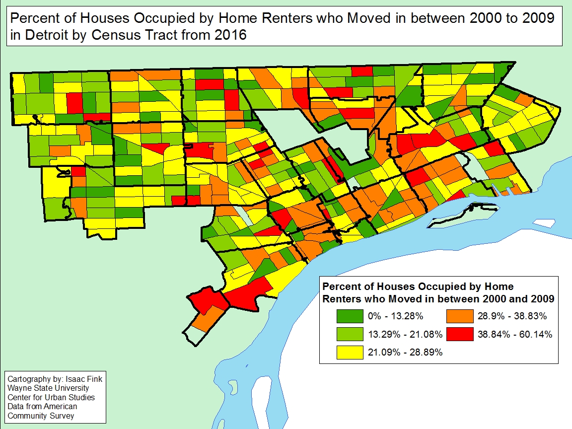
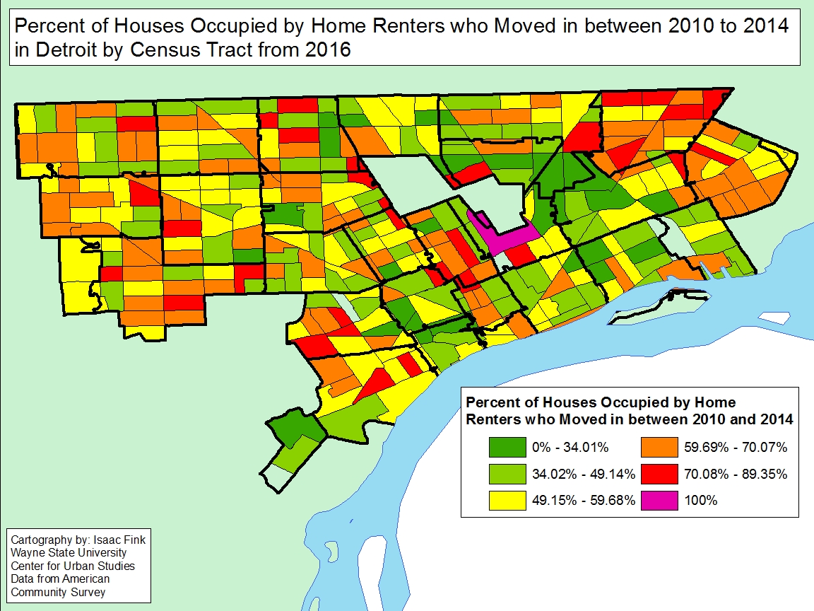
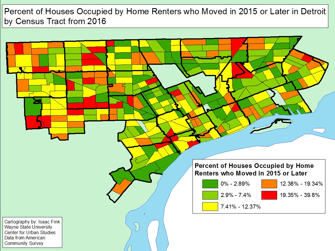
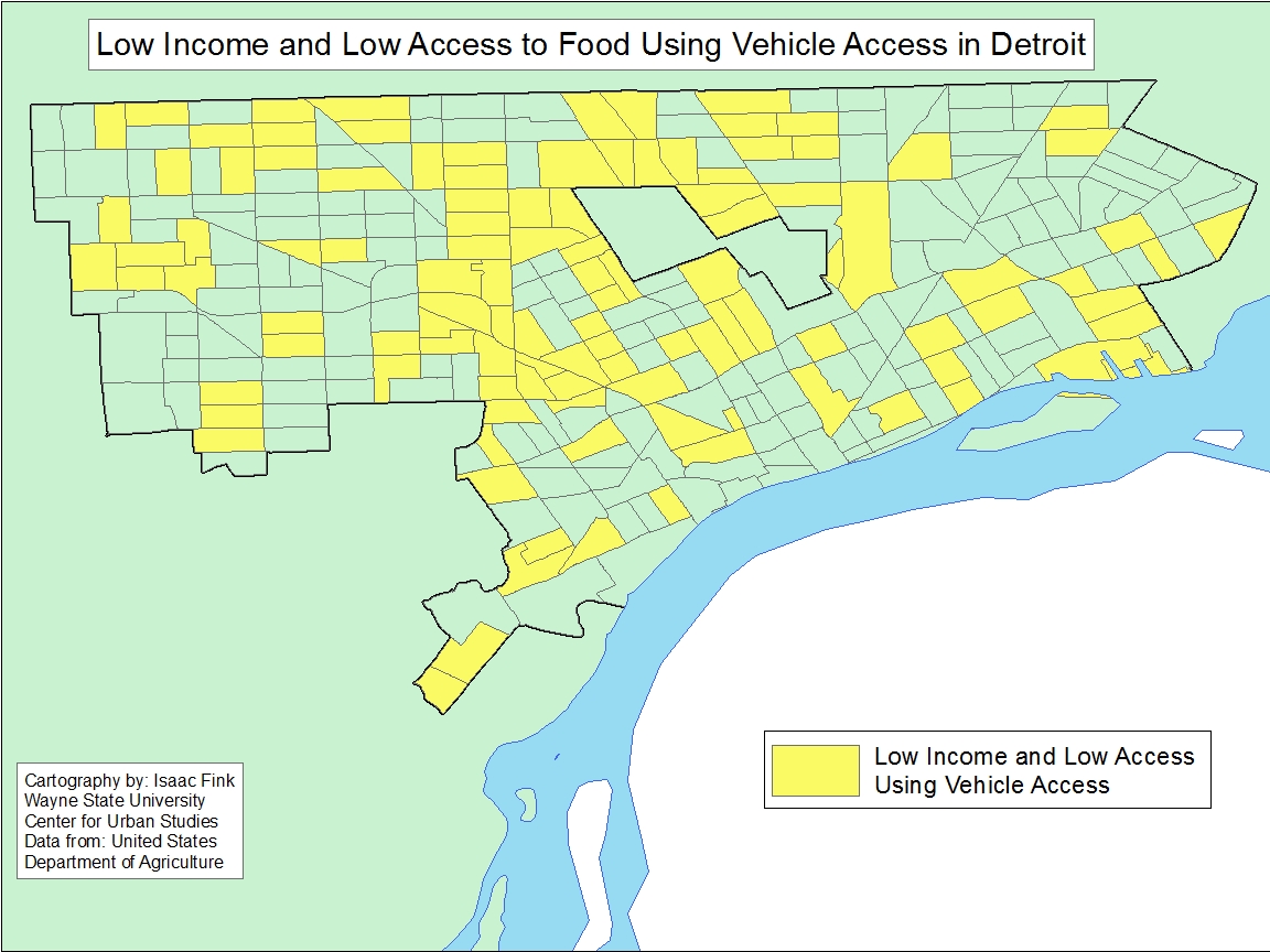
The Federal Bureau of Investigation recently released data on known criminal offenses for the year 2016. For this post, these criminal offenses have been turned into rates per 100,000 residents to accurately show how reported crimes differ between the some of the most well known cities in each county in Southeastern Michigan.

The cities featured in this post are

  • Ann Arbor: Washtenaw County
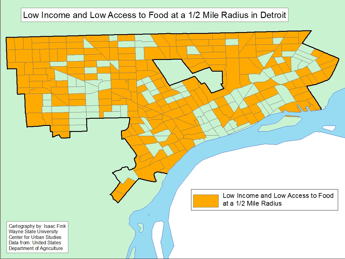
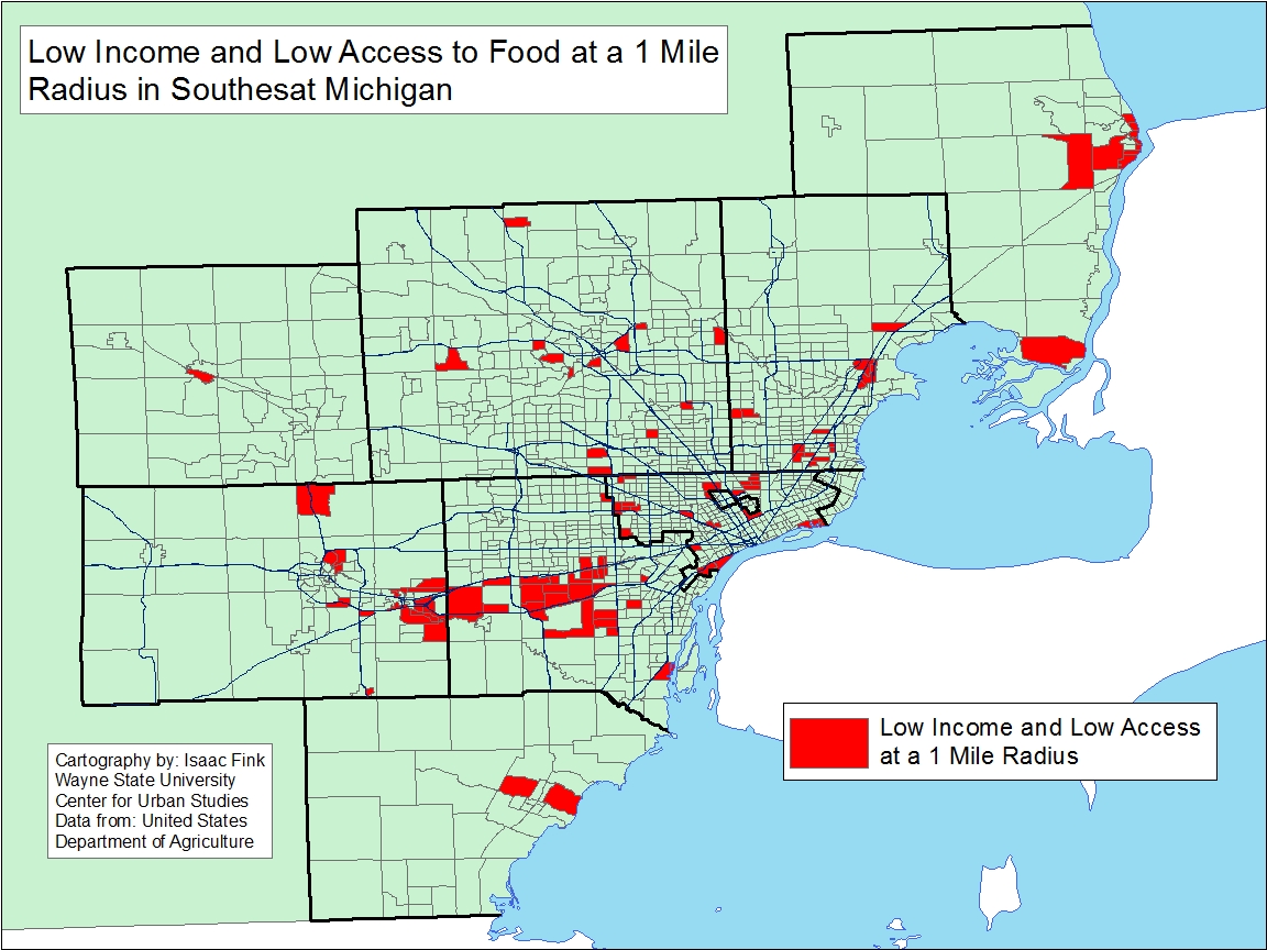
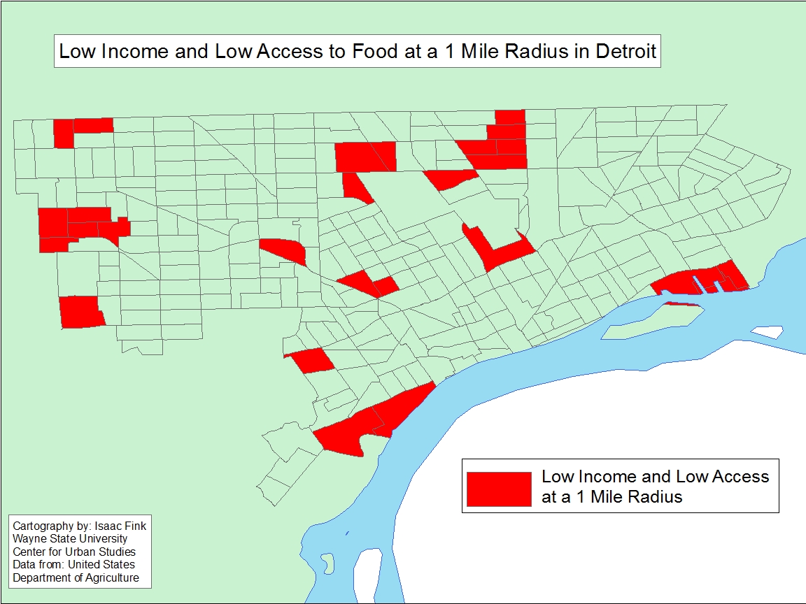
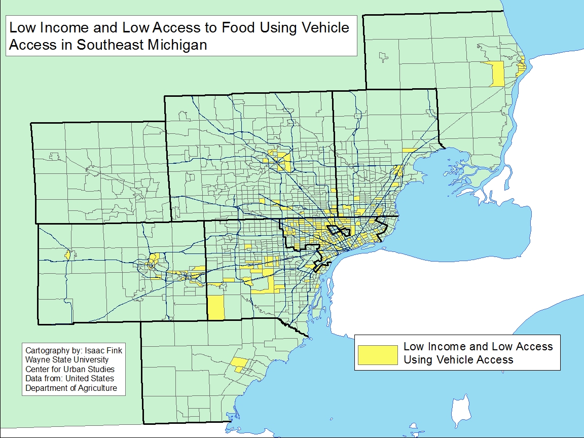
  • Detroit: Wayne County
  • Howell: Livingston County
  • Pontiac: Oakland County
  • Port Huron: St. Clair County
  • Warren: Macomb County

*Note: Information on cities in Monroe County were not part of the report.

Of the nine crimes featured, Detroit had the highest rate of the eight featured crimes for all but one. Conversely, of the nine featured crimes, Howell had the lowest rates for six of them.

Overall, property crimes had the overall highest rates of the crimes discussed in this post while murder and non-negligent manslaughter had the lowest. Property crime rates also had the largest difference between the city with the highest rate (Detroit) and the city with the lowest rate (Howell).

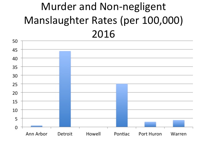
According to the FBI, Detroit had the highest murder and non-negligent manslaughter rates in 2016 of the six cities examined in this post. This rate was calculated to be 44 per 100,000 residents; this was equivalent to 303 murders for a population of about 680,000. Between 2015 and 2016 the murder rate remained the same because the population numbers and the number of reported murders and non-negligent manslaughter crimes (295 reported in 2015) didn’t vary much from year-to-year.

Howell was the only one of the six cities with zero reported murders in 2016, and therefore had a murder rate of zero.

According to the FBI forcible rape is defined as “the carnal knowledge of a female forcibly and against her will.  Attempts or assaults to commit rape by force or threat of force are also included; however, statutory rape (without force) and other sex offenses are excluded.”

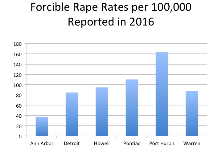
In 2016, of the cities highlighted in this post, Port Huron had the highest reported rape rate per 100,000 residents at 163; this was equivalent 48 reported rapes reported to law enforcement for a population of about 60,000. In 2015, the reported rape rate in Port Huron was 104.

Ann Arbor had the lowest rate at 37, which was equivalent to 44 total rapes known to law enforcement. Detroit’s forcible rape rate per 100,000 residents was 85 in 2016, or 579 total rapes known to law enforcement.


According to the FBI robbery is defined as “the taking or attempting to take anything of value from the care, custody, or control of a person or persons by force or threat of force or violence and/or by putting the victim in fear.”

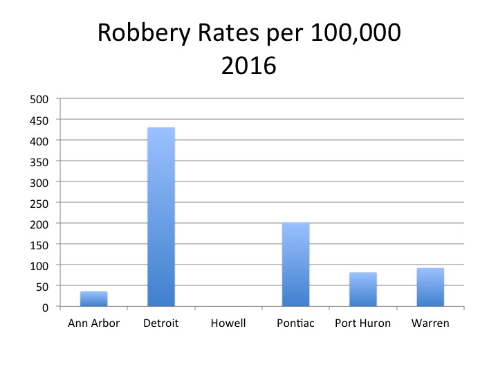
Of the featured cities, Detroit had the highest robbery rate per 100,000 at 430, a decrease from the 2015 rate of 510. According to the data, the number of reported robberies in 2016 were 2,941 in Detroit.

Pontiac had the second highest robbery rate in 2016 at 202 and Howell had the lowest rate at 0.

According to the FBI, aggravated assault is defined as “an unlawful attack by one person upon another for the purpose of inflicting severe or aggravated bodily injury.”

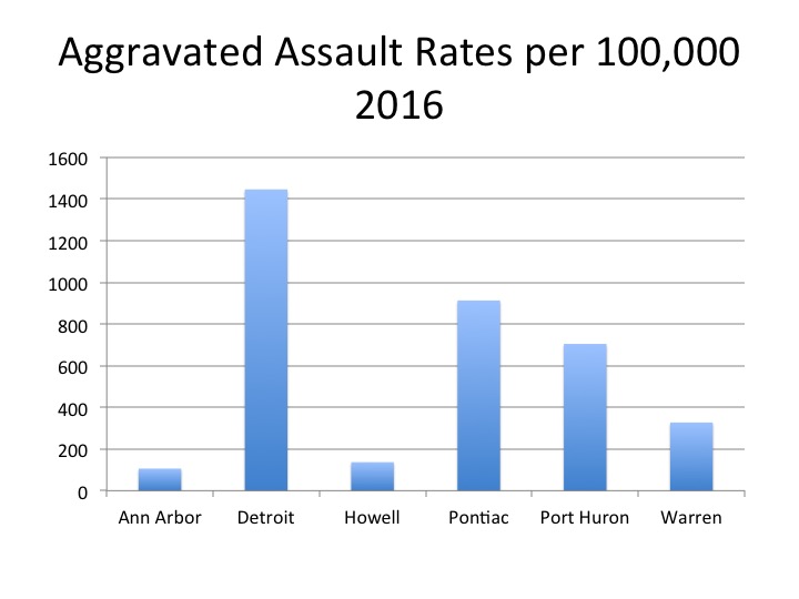
In 2016 Detroit had the highest aggravated assault rate of the cities featured in this post. Detroit’s 2016 rate was about 1,446 per 100,000 residents, a rate that was about 320 points higher than the 2015 rate. In 2016, Pontiac had the second highest rate at 913, which was about the same rate for the city in 2015. Ann Arbor had the lowest aggravated assault rate of the six cities featured at 106.

According to the FBI, property crime “includes the offenses of burglary, larceny-theft, motor vehicle theft, and arson.  The object of the theft-type offenses is the taking of money or property, but there is no force or threat of force against the victims.”

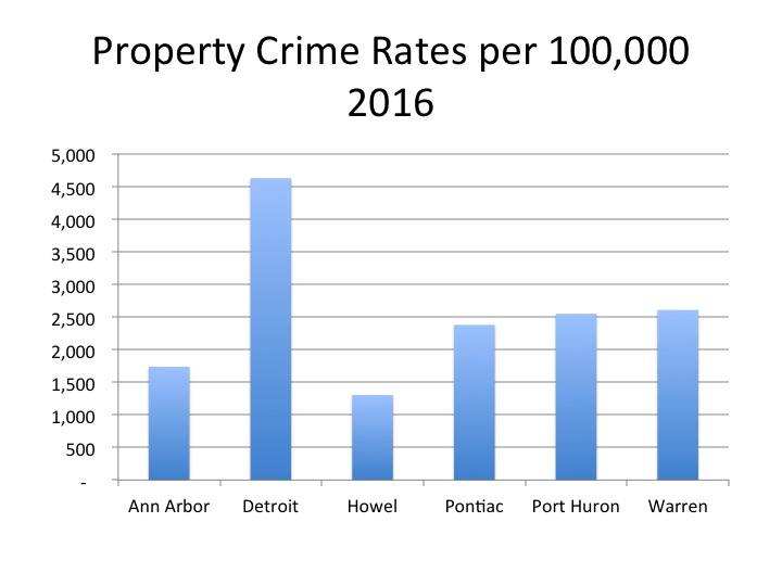
Detroit had the highest property crime rate of the six cities featured at 4,628 per 100,000 residents in 2016; this was an increase from the 4,092 rate Detroit had in 2015. The city with the second highest property crime rate was Warren at 2,607 per 100,000. Howell had the lowest rate of the featured cities at 1,304; this rate decreased by about 200 from the year before. There was a 3,324 point difference between Howell and Detroit, making this the largest rate difference of the featured cities.

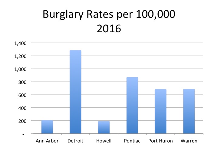
According to the FBI burglary is defined as, “the unlawful entry of a structure to commit a felony or theft.  To classify an offense as a burglary, the use of force to gain entry need not have occurred.”

Detroit’s burglary rate per 100,000 residents in 2016 was 1,286, making it the highest of the featured cities. Additionally, similar to what the data was shown for the other categories in this post, Detroit experienced rate increase for burglary from 2015 to 2016. In 2015 the burglary rate for Detroit was 1,164 and in 2016 it increased to 1,286.

Howell again had the lowest rate of the cities at 189. Although Howell’s rate was significantly lower than the City of Detroit’s, Howell also experienced a burglary rate increase between 2015 and 2016.

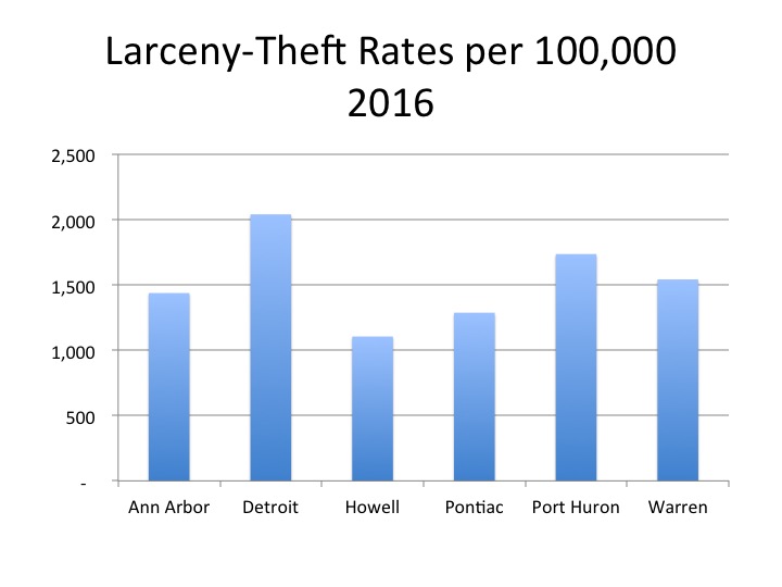
According to the FBI, larceny theft is defined as “the unlawful taking, carrying, leading, or riding away of property from the possession or constructive possession of another.”

Detroit had the highest larceny-theft rates of the featured cities in 2016 at 2,039 and Port Huron came in second at 1,735.

Detroit’s rate was equivalent to 13,938 reported crimes for a population of about 680,000 while Port Huron’s rate was equivalent to 510 reported crimes for a population of about 29,000. Howell again had the lowest rate at 1,104; this was equivalent to 105 reported crimes for a population about about 9,600.

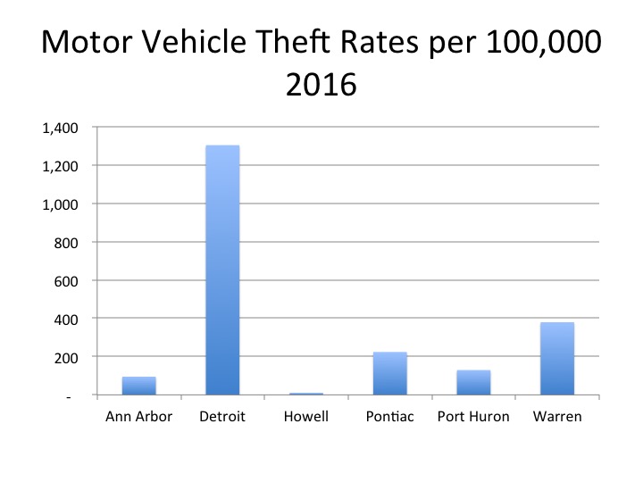
According to the FBI, motor vehicle theft is defined as “the theft or attempted theft of a motor vehicle.”

The highest motor vehicle theft rate of the featured cities was 1,303 per 100,000 residents for the City of Detroit, nearly a 530 point rate increase from 2015. This rate was equivalent to 8,905 motor vehicle thefts for a population about 680,000. The city with the second highest motor vehicle theft rate was Warren with a rate of 379. In 2016 Warren had 512 reported motor vehicle thefts for a population of about 135,000. Ann Arbor had the lowest motor vehicle theft rate of 95 per 100,000 residents in 2016 of the featured cities.

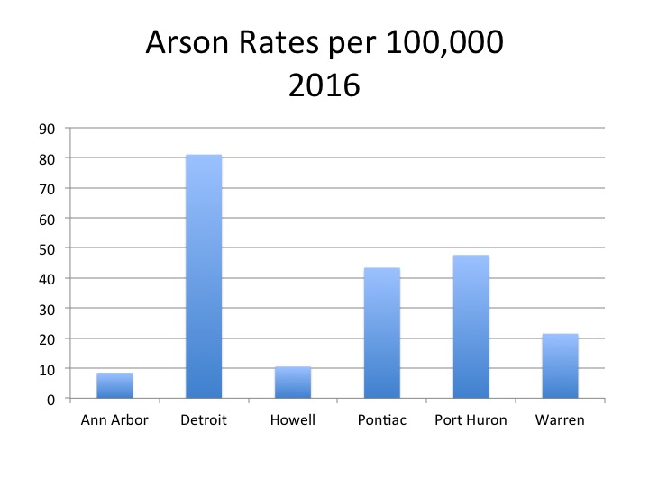
According to the FBI, arson is “any willful or malicious burning or attempting to burn, with or without intent to defraud, a dwelling house, public building, motor vehicle or aircraft, personal property of another, etc.”

Detroit had 554 reported arsons in 2016, giving it the highest rate at 81, while Ann Arbor had 10 reported arsons for a rate of 8.


Populations Living with Disabilities, in Poverty Overlap in Metro-Detroit

In 2016 Royal Oak Charter Township had the highest percentage of residents with disabilities at 29 percent, according to the U.S. Census Bureau. The five cities in the region with the highest percentage of residents with disabilities were:

Royal Oak charter township 29
Hazel Park city 25.8
Port Huron city 23.7
Memphis city 22.6
Highland Park city 22

According to the U.S. Census Bureau, the determination of an individual’s disability status is complex, as it is an umbrella concept that covers various aspects of an individual’s health. For the American Community Survey (ACS), the data set on which this post is based, individuals self-report if they have a disability based on standardized questions from the U.S. Department of Health and Human Services, per section 4302 of the Affordable Care Act.

Regionally, the average percentage of residents with a disability was 12.5 percent. Of the 210 communities for which data was available, 90 communities had more than 12.5 percent of the population classified as having disabilities. The map shows that the eastern portion of the region, from Monroe County up through St. Clair County, had the most communities in Southeastern Michigan with above average percentages of residents with disabilities. Several of these communities also had among the highest poverty rates.

The City of Detroit is an example of a community with above average disability and poverty rates. In 2016, 21.7 percent of the population in Detroit had a disability, and 39.4 percent were living at or below the poverty level. The average poverty rate for Southeastern Michigan in 2016 was 10.3, according to the ACS. The second map below further highlights how the Census tracts with among the highest percentages of the population living with a disability also had some of the highest rates of those residents living in poverty. There were 30 Census tracts where between about 68 and 86 percent of the populations had a disability and was living in poverty. Conversely, there were also about 29 Census tracts where less than 30 percent of the population had a disability and was living in poverty. Overall though, majority of the Detroit’s population that had a disability was living in poverty, according to the 2016 ACS data.

Research shows that those living in poverty have a higher risk of having a disability because they have more limited access to basic necessities (clean water, health care), are more likely to live in more dangerous environments (low quality housing, closer to natural disaster zones and environmental hazards) and are more likely to accept high risk jobs. Conversely, people with a disability have a higher chance of living in poverty due to higher costs of living as it relates to medical care and the limited opportunities that may occur due to the disability. Disability can, thus, be viewed as both a cause and consequence of poverty.

The information below shows the communities with the highest disability rates in the region, along with their poverty rates. All five of the communities, with the exception of Memphis, had above average disability and poverty rates. In 2016, the average percentage of residents in Southeastern Michigan living with a disability was 12.5, and the average percentage of residents living below the poverty line was 10.3.

Disability Rate Poverty Rate
Royal Oak Charter Township 29 31.5
Hazel Park 25.8 25.2
Port Huron 23.7 27.8
Memphis 22.6 8.8
Hazel Park 22 46.8


Overall, these data add to the narrative that poverty is a cause and consequence of disability.

Food Least Accessible for Detroit in Southeastern Michigan

Throughout Southeastern Michigan the City of Detroit had the highest number of Census tracts with the lowest access to food sources, according to 2015 data from the U.S. Department of Agriculture (USDA). For the purpose of this post, low income is defined as Census tracts with a poverty rate of 20 percent of higher or with a median family income less than 80 percent of median family income for the state or metropolitan area. Areas with low access to food are identified as Census tracts having 33 percent of the population living within a certain mileage from a grocery store. In this post these areas are identified by either being a half-mile or mile from a grocery store in an urban area and 10 miles in a rural area (these differences are identified in each map below). According to the USDA, none of the counties and/or Census tracts in Southeastern Michigan are identified as rural, so the 10 mile rural identifier will not be used in this post.

Half-mile  Mile

When examining the Southeastern Michigan region for the number of Census tracts with low-income families and low access to food sources within a half-mile majority of the City of Detroit is highlighted in the map below, in addition to Hamtramck and Highland Park. There were also several Census tracts just outside the border of Detroit, in areas including Warren, Eastpointe, Dearborn, Hazel Park and Southfield, that had low incomes and low access to reliable food sources. While there were several Census tracts in every one of the seven counties in the Southeastern Michigan region, it was Wayne County that had the had the highest number of residents with low incomes and low access to grocery stores within a half-mile of residents’ homes.

A closer look at just the Census tracts in the City of Detroit show that there were only a select number of pockets in the City that were not considered low income and also had access to a grocery store closer than a half-mile. One such area that stands out is the downtown area. Other areas include the Denby, Cody Rouge and West Village neighborhoods.

In Washtenaw County, it was the Ann Arbor/Ypsilanti area that had the highest number of Census tracts with low-income families not having access to grocery stores and in Oakland County, beyond those Census tracts that border Detroit, it was the Pontiac that had the most number of low-income residents with low access to food options. In the less densely populated counties in the region (Monroe, St. Clair, Livingston) there was an average of about three Census tracts with a poverty rate of 20 percent of higher or with a median family income less than 80 percent of median family income and access to a grocery store more than a half-mile away.

One Mile

When the radius was expanded to one mile, the number of Census tracts without access to grocery stores dramatically decreased. The most notable decrease in the region was in the City of Detroit. In the maps below there are only about 20 Census tracts in the City of Detroit with a poverty rate of 20 percent of higher or with a median family income less than 80 percent of median family income and access to a grocery store more than a mile away. In the maps above, which depict access within a half-mile, nearly the entire City is highlighted for low income and low access. A notable difference due to access between a half-mile and mile can also be seen in the Ypsilanti/Ann Arbor area.

Throughout Livingston, Monroe and St. Clair counties there was a minimum decrease in the number of Census tracts with a poverty rate of 20 percent of higher or with a median family income less than 80 percent of median family income and access to a grocery store more than a half-mile away.

Low Income and Low Vehicle Access

The maps below identify low-income Census tracts where more than 100 housing units did not have a vehicle and were more than a half-mile from the nearest grocery store. When applying these variables we see there was an overall fewer number of Census tracts without access than when only looking at access, despite transportation accessibility. This was particularly true throughout Wayne County and in Census tracts just north of Wayne County. In Detroit, the highest concentration of Census tracts with more than 100 housing units not having a vehicle and that were more than a half-mile from the nearest grocery store were those on the west side of the City along Livernois Avenue.

In examining the data provided by the USDA, we see that regionally it was the City of Detroit, its inner-ring suburbs that had the highest number of low-income families with among the lowest access to food due to the location of grocery stores in 2015. To help support access to grocery stores, a robust public transportation network could be one solution, particularly in Detroit and its surrounding cities. Additionally, it is also important to understand the impact low incomes have on families when it comes to accessing healthy foods. While grocery stores may be within a half-mile or mile from a home, once an individual reaches a grocery store the chances of them purchasing fresh, non-processed foods may not be as high due to cost, and quite possibly access within the store. To support access to fresh foods in urban areas like the City of Detroit the Detroit Food Justice Task Force recommends policies that allow for more support of neighborhood famers markets and small businesses and research that identifies the food needs of neighborhoods throughout the City.

Maternal Deaths Highest in Detroit

A look into the pregnancy related death rates in Southeastern Michigan showed that the City of Detroit had higher rates from 2008-13 (combined) than any other governmental unit reported for the region. The Michigan Department of Health and Human Services says pregnancy related deaths are those when a woman dies while pregnant or within one year of pregnancy from any cause related to, or aggravated by, pregnancy or its management. According to MDHHS data, the pregnancy related death rate for Detroit was 44.4 per 100,000 babies from 2007-13 (44.4 total). Pregnancy associated deaths, by contrast are those that occur while a woman is pregnant or within a year of pregnancy irrespective of cause; these deaths can include suicide, drug overdoses or medical causes such as cancer. The rate for Detroit was 62.7 per 100,000 babies for pregnancy associated deaths (48 total) from 2007-13. When comparing pregnancy associated deaths and pregnancy related deaths, the data shows that there were overall higher rates for pregnancy associated deaths. This is likely because pregnancy associated deaths encompasses a broader range of causes of death.

As stated, the data provided by the Michigan Department of Health and Human Services shows that Detroit had the highest rate of pregnancy related death and pregnancy associated death rates in the region. For pregnancy related deaths, Wayne County had the lowest rate at 9.5 per 100,000 babies (9 total), for the counties where data were available. Wayne County’s rate excludes the deaths in the City of Detroit. In Southeastern Michigan pregnancy related rates for Livingston, Monroe, St. Clair and Washtenaw counties were not available because there were five or less deaths.

For pregnancy associated deaths Oakland County had the overall lowest rate at 28.6 (7 total). In Southeastern Michigan, pregnancy associated rates for Livingston, Monroe and Washtenaw counties were not available because there were five or less deaths.

According to an article from the Detroit News, high maternal death rates are related to chronic health conditions and high rates of poverty, both of which are common in Detroit.

The Michigan Department of Health and Human Services does not have data for 2014 and 2015 because it had not been reviewed by the State’s maternal death committees, as of early December, according to a representative from the department. In early 2017, Public Act 479 of 2016 was signed into law making maternal death reporting mandatory. Prior to this law reporting was voluntary.